IMAGES TAKEN NEAR TO
Libeneth Road, NEWPORT, NP19 9AP
Introduction
This page details the photographs taken nearby to Libeneth Road, NP19 9AP by members of the Geograph project.
The Geograph project started in 2005 with the aim of publishing, organising and preserving representative images for every square kilometre of Great Britain, Ireland and the Isle of Man.

There are currently over 7.5m images from over14,400 individuals and you can help contribute to the project by visiting https://www.geograph.org.uk
Image Map
Images are licensed for reuse under creativecommons.org/licenses/by-sa/2.0
Notes
- Clicking on the map will re-center to the selected point.
- The higher the marker number, the further away the image location is from the centre of the postcode.
Image Listing (190 Images Found)
Images are licensed for reuse under creativecommons.org/licenses/by-sa/2.0
Image
Details
Distance
1
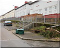
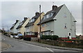
Lime Crescent, Newport
Houses on the east side of Lime Crescent, viewed from the corner of Libeneth Road. Lime Crescent rejoins Libeneth Road about 60 metres east of here.
Image: © Jaggery
Taken: 28 Jan 2010
0.03 miles
2
Steps to elevated pavement, Laburnum Drive, Newport
Image: © Jaggery
Taken: 7 Feb 2010
0.07 miles
3
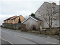
Libeneth Road approaching the eastern end of Lime Crescent, Newport
Houses on the north side of Libeneth Road, between the west and east junctions with Lime Crescent.
On the other side of the road is the South Wales main railway lime.
Image: © Jaggery
Taken: 28 Jan 2010
0.07 miles
4
Newport MOT & Repair Centre, Libeneth Road
Located at the far end of Libeneth Road, next to the last house and set back several metres from the road.
Image: © Jaggery
Taken: 28 Jan 2010
0.07 miles
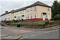
6
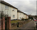
Libeneth Road houses, Newport
Houses on the south side of Libeneth Road, close to the roundabout http://www.geograph.org.uk/photo/1683011 at the corner of Hawthorn Avenue.
Image: © Jaggery
Taken: 28 Jan 2010
0.10 miles
7
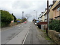
Libeneth Road, Newport
Libeneth Road climbs away from the corner of Hawthorn Avenue. http://www.geograph.org.uk/photo/1683011
Image: © Jaggery
Taken: 28 Jan 2010
0.10 miles
8
Laburnum Drive, Newport
Houses on the east side of the southern end of Laburnum Drive, viewed from Libeneth Road.
Image: © Jaggery
Taken: 28 Jan 2010
0.10 miles
9
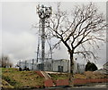
Mobile phone mast, Libeneth Road, Newport
The mast is located on the highest point on Libeneth Road. Most of Newport to the south of this point is flat land, unlike the very hilly terrain in most of the northern part of the city.
Image: © Jaggery
Taken: 28 Jan 2010
0.10 miles
10
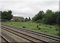
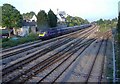
View from a Bristol-Cardiff train - East Usk Junction
A short freight branch to the right, runs along the east side of the River Usk.
Image: © Nigel Thompson
Taken: 14 Aug 2015
0.11 miles