IMAGES TAKEN NEAR TO
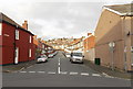
Chepstow Road, NEWPORT, NP19 8NN
Introduction
This page details the photographs taken nearby to Chepstow Road, NP19 8NN by members of the Geograph project.
The Geograph project started in 2005 with the aim of publishing, organising and preserving representative images for every square kilometre of Great Britain, Ireland and the Isle of Man.

There are currently over 7.5m images from over14,400 individuals and you can help contribute to the project by visiting https://www.geograph.org.uk
Image Map
Images are licensed for reuse under creativecommons.org/licenses/by-sa/2.0
Notes
- Clicking on the map will re-center to the selected point.
- The higher the marker number, the further away the image location is from the centre of the postcode.
Image Listing (185 Images Found)
Images are licensed for reuse under creativecommons.org/licenses/by-sa/2.0
Image
Details
Distance
1
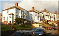
Tennyson Road, Newport
Houses on the north side of Tennyson Road, between Chepstow Road and Milton Road.
Image: © Jaggery
Taken: 24 Jan 2010
0.02 miles
2
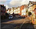
St Johns Road, Beechwood
Houses on the east side of St Johns Road.
As with other Beechwood roads connecting with the north side Chepstow Road, St Johns Road rises steeply away from the flatter, southern part of Newport.
Image: © Jaggery
Taken: 24 Jan 2010
0.02 miles
3
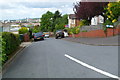
Shelley Road, Newport
Viewed from Milton Road. Shelley Road is a very short cul-de-sac of four houses, (numbered 2,4,6,8), all on the right (north) side of the road.
Image: © Jaggery
Taken: 9 Jun 2012
0.02 miles
4
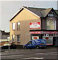
Flower Power van on an Eveswell corner, Newport
The florists' van is parked on the corner of Rothesay Road and Chepstow Road, opposite St John's Road.
Image: © Jaggery
Taken: 23 Dec 2015
0.02 miles
5
Rothesay Road, Newport
Viewed from Conway Road. Rothesay Road extends for 150 metres towards Chepstow Road near the St Johns Road junction.
Image: © Jaggery
Taken: 5 Jan 2013
0.02 miles
6
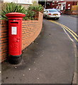
King George V pillarbox on a Beechwood corner, Newport
On the corner of Chepstow Road and St John's Road. http://www.geograph.org.uk/photo/4773415
The letters GR on the box date it to the reign of King George V (May 1910-January 1936).
Image: © Jaggery
Taken: 23 Dec 2015
0.02 miles
7
Pillarbox on a Beechwood corner, Newport
King George V pillarbox http://www.geograph.org.uk/photo/4773395 on the corner of Chepstow Road and St John's Road.
Image: © Jaggery
Taken: 23 Dec 2015
0.02 miles
8
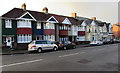
Seven gables on the south side of Chepstow Road, Newport
The row extends for 50 metres from the corner of Carisbrooke Road on the left to the corner
of Arundel Road on the right. Houses on the left, business premises on the right.
Image: © Jaggery
Taken: 23 Dec 2015
0.02 miles
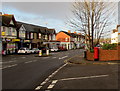
9
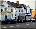
Three Beechwood businesses, Newport
On the south side of Chepstow Road, opposite Tennyson Road.
The office of Paul L. Williams solicitors is on the left.
Next door is Adorn Hair Studio. On the right, Arthur J. Gallagher
insurance brokers at 296 Chepstow Road is on the corner of Arundel Road.
Image: © Jaggery
Taken: 23 Dec 2015
0.02 miles
10
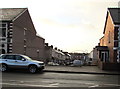
Northern end of Arundel Road, Newport
Viewed across Chepstow Road. Metal railings, brick walls and a ramp below
Chepstow Road block off a former through route for vehicles to Conway Road.
Image: © Jaggery
Taken: 23 Dec 2015
0.02 miles