IMAGES TAKEN NEAR TO
Crescent Court, NEWPORT, NP19 8LU
Introduction
This page details the photographs taken nearby to Crescent Court, NP19 8LU by members of the Geograph project.
The Geograph project started in 2005 with the aim of publishing, organising and preserving representative images for every square kilometre of Great Britain, Ireland and the Isle of Man.

There are currently over 7.5m images from over14,400 individuals and you can help contribute to the project by visiting https://www.geograph.org.uk
Image Map
Images are licensed for reuse under creativecommons.org/licenses/by-sa/2.0
Notes
- Clicking on the map will re-center to the selected point.
- The higher the marker number, the further away the image location is from the centre of the postcode.
Image Listing (137 Images Found)
Images are licensed for reuse under creativecommons.org/licenses/by-sa/2.0
Image
Details
Distance
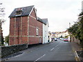
1
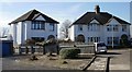
Lincoln Close, Newport
Houses at the end of Lincoln Close, a short street on the south side of Christchurch Road.
Image: © Jaggery
Taken: 4 Mar 2010
0.03 miles
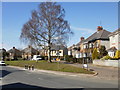
2
Western end of Crescent Road, Newport
Looking east across Victoria Avenue from the corner of Brynderwen Road.
Image: © Jaggery
Taken: 10 Jun 2016
0.04 miles
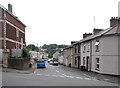
3
Cardigan Place, Newport
Viewed from the corner of Northumberland Road, which connects with Christchurch Road.
Image: © Jaggery
Taken: 4 Mar 2010
0.04 miles
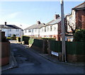
4
Northumberland Road, Newport
Houses on the west side of the road, viewed from the Christchurch Road end. In the distance is the turning for Cardigan Place. http://www.geograph.org.uk/photo/1739326
Image: © Jaggery
Taken: 4 Mar 2010
0.04 miles
5
Crescent Road, Newport
Crescent Road viewed from the junction of Woodland Road and Woodland Park Road.
Image: © Jaggery
Taken: 1 Nov 2009
0.05 miles
6
Change of house type, Christchurch Road, Newport
Looking west along Christchurch Road from the corner of Buckingham Crescent.
Image: © Jaggery
Taken: 10 Jun 2016
0.06 miles
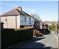
7
Buckingham Crescent, Newport
Buckingham Crescent is really just a slight deviation in the line of houses along the north side of Christchurch Road : there are no houses on the south side of the crescent, nor on the north side of Christchurch Road adjacent to the crescent.
A very short street, Buckingham Place, http://www.geograph.org.uk/photo/1739373 heads north from the midpoint of the crescent.
Image: © Jaggery
Taken: 4 Mar 2010
0.06 miles
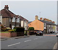
8
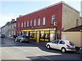
Beechwood Stores, Newport
Convenience stores at 88 Christchurch Road.
Image: © Jaggery
Taken: 4 Mar 2010
0.06 miles
9
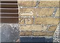
Ordnance Survey Cut Mark
This OS cut mark can be found on No116 Christchurch Road. It marks a point 60.125m above mean sea level.
Image: © Adrian Dust
Taken: 9 Jun 2018
0.06 miles
10
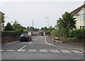
Junction of Christchurch Road and Lincoln Close, Newport
Viewed across Christchurch Road. Lincoln Close is a cul-de-sac. These http://www.geograph.org.uk/photo/1739346 houses are at its far end.
Image: © Jaggery
Taken: 10 Jun 2016
0.07 miles