IMAGES TAKEN NEAR TO
Brynderwen Grove, NEWPORT, NP19 8LP
Introduction
This page details the photographs taken nearby to Brynderwen Grove, NP19 8LP by members of the Geograph project.
The Geograph project started in 2005 with the aim of publishing, organising and preserving representative images for every square kilometre of Great Britain, Ireland and the Isle of Man.

There are currently over 7.5m images from over14,400 individuals and you can help contribute to the project by visiting https://www.geograph.org.uk
Image Map
Images are licensed for reuse under creativecommons.org/licenses/by-sa/2.0
Notes
- Clicking on the map will re-center to the selected point.
- The higher the marker number, the further away the image location is from the centre of the postcode.
Image Listing (258 Images Found)
Images are licensed for reuse under creativecommons.org/licenses/by-sa/2.0
Image
Details
Distance
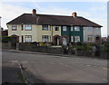
1

Elevated houses, Christchurch Road, Newport
Houses on the north side of Christchurch Road, between Cornwall Road and Radnor Road, are based several metres above street level.
Image: © Jaggery
Taken: 4 Mar 2010
0.03 miles
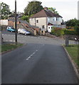
2
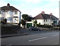
Junction of Brynderwen Grove and Christchurch Road, Newport
The car is in Brynderwen Grove.
Image: © Jaggery
Taken: 7 Aug 2018
0.03 miles
3

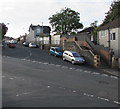
Steps on the corner of Brynderwen Road, Newport
Viewed from the corner of Cornwall Road. Steps lead up to the elevated pavement on the south side of Brynderwen Road.
Image: © Jaggery
Taken: 4 Mar 2010
0.03 miles
4

Brynderwen Grove, Newport
Houses on the south side of Brynderwen Grove, viewed from the corner of Christchurch Road. Brynderwen Grove is a short cul-de-sac.
Image: © Jaggery
Taken: 4 Mar 2010
0.03 miles
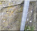
5
Ordnance Survey Cut Mark
This OS cut mark can be found on the wall SE side of Brynderwen Road. It marks a point 47.918m above mean sea level.
Image: © Adrian Dust
Taken: 9 Jun 2018
0.04 miles
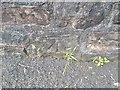
6
Ordnance Survey Cut Mark
This OS cut mark can be found on the wall of No26A Christchurch Road. It marks a point 34.546m above mean sea level.
Image: © Adrian Dust
Taken: 9 Jun 2018
0.04 miles
7
Row of four houses, Christchurch Road, Newport
Opposite Somerset Road.
Image: © Jaggery
Taken: 7 Aug 2018
0.04 miles
8
Junction of Cornwall Road and Christchurch Road, Newport
Cornwall Road descends to Christchurch Road.
Image: © Jaggery
Taken: 7 Aug 2018
0.04 miles
9
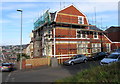
Scaffolding on the corner of Somerset Road and Christchurch Road, Newport
Viewed on August 7th 2018.
Image: © Jaggery
Taken: 7 Aug 2018
0.04 miles
10
Western end of Brynderwen Road, Newport
Viewed across Christchurch Road from the corner of Cornwall Road.
Image: © Jaggery
Taken: 7 Aug 2018
0.04 miles