IMAGES TAKEN NEAR TO
St. Johns Road, NEWPORT, NP19 8GW
Introduction
This page details the photographs taken nearby to St. Johns Road, NP19 8GW by members of the Geograph project.
The Geograph project started in 2005 with the aim of publishing, organising and preserving representative images for every square kilometre of Great Britain, Ireland and the Isle of Man.

There are currently over 7.5m images from over14,400 individuals and you can help contribute to the project by visiting https://www.geograph.org.uk
Image Map
Images are licensed for reuse under creativecommons.org/licenses/by-sa/2.0
Notes
- Clicking on the map will re-center to the selected point.
- The higher the marker number, the further away the image location is from the centre of the postcode.
Image Listing (189 Images Found)
Images are licensed for reuse under creativecommons.org/licenses/by-sa/2.0
Image
Details
Distance
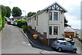
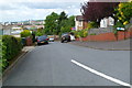
1
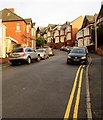
St John's Road, Beechwood, Newport
One of several steep streets on the north side of Chepstow Road.
Image: © Jaggery
Taken: 23 Dec 2015
0.01 miles
2
Junction of Milton Road, Chaucer Road and Wordsworth Road, Newport
Viewed from Milton Road, which becomes Chaucer Road on passing the right turn into Wordsworth Road.
Image: © Jaggery
Taken: 9 Jun 2012
0.02 miles
3
Southern end of Chaucer Road, Newport
Viewed from the right turn into Wordsworth Road which marks the northern end of Milton Road and the southern end of Chaucer Road.
Image: © Jaggery
Taken: 9 Jun 2012
0.02 miles
4
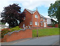
The Beeches, Chaucer Road, Newport
Recently-built detached house in a semi-elevated position on the north side of Chaucer Road.
Image: © Jaggery
Taken: 9 Jun 2012
0.02 miles
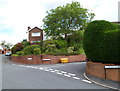
5
Rosendale Court, Newport
Rosendale Court is a short cul-de-sac on the east side of Eveswell Park Road.
The parked car gives a good indication of the steepness of the roads hereabouts.
Image: © Jaggery
Taken: 9 Jun 2012
0.02 miles
6
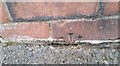
Ordnance Survey Cut Mark
This is all that remains of an OS cut mark which can be found on the wall of No14 Bachelor Road. It marked a point 23.863m above mean sea level.
Image: © Adrian Dust
Taken: 9 Jun 2018
0.04 miles
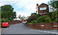
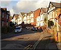
7
Tennyson Road, Newport
Houses on the north side of Tennyson Road, between Chepstow Road and Milton Road.
Image: © Jaggery
Taken: 24 Jan 2010
0.05 miles
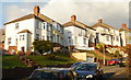
8
St Johns Road, Beechwood
Houses on the east side of St Johns Road.
As with other Beechwood roads connecting with the north side Chepstow Road, St Johns Road rises steeply away from the flatter, southern part of Newport.
Image: © Jaggery
Taken: 24 Jan 2010
0.05 miles
9
Shelley Road, Newport
Viewed from Milton Road. Shelley Road is a very short cul-de-sac of four houses, (numbered 2,4,6,8), all on the right (north) side of the road.
Image: © Jaggery
Taken: 9 Jun 2012
0.05 miles
10
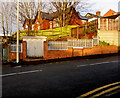
Tennyson Road electricity substation, Newport
Western Power Distribution electricity substation located at the bottom of Tennyson Road,
near the corner of Chepstow Road. Its identifier is TENNYSON RD. NPT. S/S No. 532528
Image: © Jaggery
Taken: 23 Dec 2015
0.05 miles