IMAGES TAKEN NEAR TO
Eveswell Park Road, NEWPORT, NP19 8GS
Introduction
This page details the photographs taken nearby to Eveswell Park Road, NP19 8GS by members of the Geograph project.
The Geograph project started in 2005 with the aim of publishing, organising and preserving representative images for every square kilometre of Great Britain, Ireland and the Isle of Man.

There are currently over 7.5m images from over14,400 individuals and you can help contribute to the project by visiting https://www.geograph.org.uk
Image Map
Images are licensed for reuse under creativecommons.org/licenses/by-sa/2.0
Notes
- Clicking on the map will re-center to the selected point.
- The higher the marker number, the further away the image location is from the centre of the postcode.
Image Listing (175 Images Found)
Images are licensed for reuse under creativecommons.org/licenses/by-sa/2.0
Image
Details
Distance
2
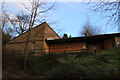
Former Kensington Court Day Centre
Kensington Court Day Centre in Maindee was built in the early 1980s. The site closed down around 2015 - 16.
Image: © superpopslive
Taken: 18 Jan 2018
0.06 miles
3
Junction of Milton Road, Chaucer Road and Wordsworth Road, Newport
Viewed from Milton Road, which becomes Chaucer Road on passing the right turn into Wordsworth Road.
Image: © Jaggery
Taken: 9 Jun 2012
0.06 miles
4
Southern end of Chaucer Road, Newport
Viewed from the right turn into Wordsworth Road which marks the northern end of Milton Road and the southern end of Chaucer Road.
Image: © Jaggery
Taken: 9 Jun 2012
0.06 miles
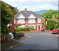
5
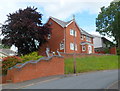
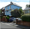
The Beeches, Chaucer Road, Newport
Recently-built detached house in a semi-elevated position on the north side of Chaucer Road.
Image: © Jaggery
Taken: 9 Jun 2012
0.06 miles
6
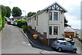
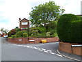
Rosendale Court, Newport
Rosendale Court is a short cul-de-sac on the east side of Eveswell Park Road.
The parked car gives a good indication of the steepness of the roads hereabouts.
Image: © Jaggery
Taken: 9 Jun 2012
0.06 miles
7
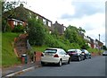
Steps up to Chaucer Road houses, Newport
This part of Newport, north of Chepstow Road, is a steep slope on the south side of Christchurch Hill. These houses are set several metres above road level.
Image: © Jaggery
Taken: 9 Jun 2012
0.06 miles
8
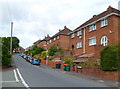
Upper Tennyson Road houses, Newport
Houses on the north side of the road, viewed from the corner of Chaucer Road.
Image: © Jaggery
Taken: 9 Jun 2012
0.06 miles
9
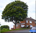
Bench with its back to a view, Upper Tennyson Road, Newport
The bench was the subject of an article in the local newspaper in 2009 and again in 2011. The paper commented "It's the Newport bench which offers views across the city, if you have eyes in the back of your head." The bench under a tree faces a house in Upper Tennyson Road. Views http://www.geograph.org.uk/photo/2985511 across Newport are in the opposite direction.
Image: © Jaggery
Taken: 9 Jun 2012
0.06 miles
10
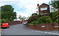
Junction of Clevedon Road and Eveswell Park Road, Newport
A view along the western end of Clevedon Road.
Image: © Jaggery
Taken: 9 Jun 2012
0.07 miles