IMAGES TAKEN NEAR TO
Victoria Lane, NEWPORT, NP19 8GN
Introduction
This page details the photographs taken nearby to Victoria Lane, NP19 8GN by members of the Geograph project.
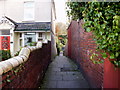
The Geograph project started in 2005 with the aim of publishing, organising and preserving representative images for every square kilometre of Great Britain, Ireland and the Isle of Man.

There are currently over 7.5m images from over14,400 individuals and you can help contribute to the project by visiting https://www.geograph.org.uk
Image Map
Images are licensed for reuse under creativecommons.org/licenses/by-sa/2.0
Notes
- Clicking on the map will re-center to the selected point.
- The higher the marker number, the further away the image location is from the centre of the postcode.
Image Listing (311 Images Found)
Images are licensed for reuse under creativecommons.org/licenses/by-sa/2.0
Image
Details
Distance
1
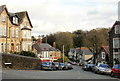
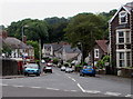
Woodland Road, Newport
Woodland Road descends from Victoria Avenue.
Image: © Jaggery
Taken: 1 Nov 2009
0.04 miles
2
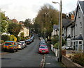
Woodland Road, Newport
Looking along the middle section of Woodland Road towards Woodland Park Road. Houses continue on the lefthand side, but on the right, the tree marks the limit of houses, and the edge of Woodland Park.
Image: © Jaggery
Taken: 1 Nov 2009
0.04 miles
3
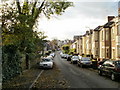
Woodland Road, Newport
Looking west along Woodland Road from the edge of Woodland Park. The car under the tree has received a thin layer of fallen leaves.
Image: © Jaggery
Taken: 1 Nov 2009
0.04 miles
4
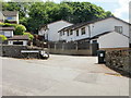
Kensington Gardens, Newport
A short cul-de-sac connecting with the northern end of Kensington Place.
Image: © Jaggery
Taken: 27 May 2010
0.04 miles
5
From Woodland Road to Victoria Avenue, Newport
The tree on the left is in the garden of a house at the western end of Woodland Road.
The WOODLAND ROAD name sign is in front of the tree.
The tree on the right is on the Victoria Avenue pavement.
Image: © Jaggery
Taken: 10 Jun 2016
0.04 miles
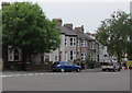
6
Three-storey houses, Woodland Road, Newport
Opposite the Victoria Avenue junction.
Image: © Jaggery
Taken: 10 Jun 2016
0.04 miles
7
Summerhill Avenue, Newport
Houses on the north side of Summerhill Avenue, viewed from the junction with Woodland Road and Victoria Avenue.
Image: © Jaggery
Taken: 1 Nov 2009
0.05 miles
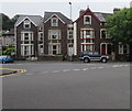
8
Victoria Lane, Newport
Viewed from Victoria Avenue, the lane heads towards Kensington Place.
Image: © Jaggery
Taken: 1 Nov 2009
0.05 miles
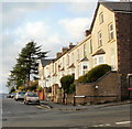
9
Western end of Woodland Road, Newport
Looking east along Woodland Road from the corner of Victoria Avenue and Summerhill Avenue.
Image: © Jaggery
Taken: 10 Jun 2016
0.06 miles
10
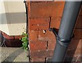
Ordnance Survey Cut Mark
This OS cut mark can be found on No49B Victoria Avenue. It marks a point 30.648m above mean sea level.
Image: © Adrian Dust
Taken: 9 Jun 2018
0.06 miles