IMAGES TAKEN NEAR TO
Christchurch Road, NEWPORT, NP19 8FN
Introduction
This page details the photographs taken nearby to Christchurch Road, NP19 8FN by members of the Geograph project.
The Geograph project started in 2005 with the aim of publishing, organising and preserving representative images for every square kilometre of Great Britain, Ireland and the Isle of Man.

There are currently over 7.5m images from over14,400 individuals and you can help contribute to the project by visiting https://www.geograph.org.uk
Image Map
Images are licensed for reuse under creativecommons.org/licenses/by-sa/2.0
Notes
- Clicking on the map will re-center to the selected point.
- The higher the marker number, the further away the image location is from the centre of the postcode.
Image Listing (497 Images Found)
Images are licensed for reuse under creativecommons.org/licenses/by-sa/2.0
Image
Details
Distance
1
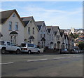
South side of Christchurch Road, Newport
On the descent towards Duckpool Road, Church Road and the city centre.
Image: © Jaggery
Taken: 7 Aug 2018
0.01 miles
2

Looking down Christchurch Road, Newport
Christchurch Road descends towards Duckpool Road and Church Road.
Houses beyond the right end of the photo are based several metres above street level. http://www.geograph.org.uk/photo/1740133
Image: © Jaggery
Taken: 4 Mar 2010
0.01 miles
3

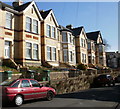
Somerset Road, Newport
Houses on the west side of Somerset Road, viewed from the Christchurch Road end.
Image: © Jaggery
Taken: 4 Mar 2010
0.01 miles
4

Morden Road, Newport
The elevated pavement on the east side of Morden Road, viewed from near the corner with Christchurch Road.
Image: © Jaggery
Taken: 4 Mar 2010
0.01 miles
5
Southeast corner of Morden Road, Newport
Houses on Morden Road near the corner of Christchurch Road.
Image: © Jaggery
Taken: 4 Mar 2010
0.01 miles
6
Church Road towards Christchurch Road, Newport
Looking east along Church Road from the corner of Caerleon Road. In the distance,
Christchurch Road begins its long ascent towards the Christchurch area of Newport.
Image: © Jaggery
Taken: 18 Nov 2017
0.02 miles
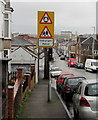
7
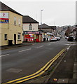
Warning signs alongside Christchurch Road, Newport
Facing vehicles descending Christchurch Road on the approach to the roundabout at
the Duckpool Road/Church Road/Fairoak Avenue crossroads viewed in August 2018.
A Welsh/English Hebryngwr/Patrol sign has replaced the English-only
sign seen in an October 2016 Google Earth Street View.
Image: © Jaggery
Taken: 7 Aug 2018
0.02 miles
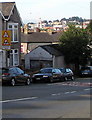
8
Warning signs, Christchurch Road, Newport
On the descent towards the Duckpool Road roundabout and Fairoak Nursery School.
The text is in Welsh and English.
Image: © Jaggery
Taken: 9 Mar 2019
0.02 miles
9
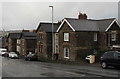
Stone houses, Christchurch Road, Newport
On the descent towards Duckpool Road and the city centre.
Image: © Jaggery
Taken: 9 Mar 2019
0.04 miles
10
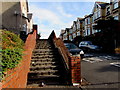
Steps up to the Morden Road pavement, Newport
From Christchurch Road.
Image: © Jaggery
Taken: 7 Aug 2018
0.04 miles