IMAGES TAKEN NEAR TO
Victoria Avenue, NEWPORT, NP19 8FD
Introduction
This page details the photographs taken nearby to Victoria Avenue, NP19 8FD by members of the Geograph project.
The Geograph project started in 2005 with the aim of publishing, organising and preserving representative images for every square kilometre of Great Britain, Ireland and the Isle of Man.

There are currently over 7.5m images from over14,400 individuals and you can help contribute to the project by visiting https://www.geograph.org.uk
Image Map
Images are licensed for reuse under creativecommons.org/licenses/by-sa/2.0
Notes
- Clicking on the map will re-center to the selected point.
- The higher the marker number, the further away the image location is from the centre of the postcode.
Image Listing (465 Images Found)
Images are licensed for reuse under creativecommons.org/licenses/by-sa/2.0
Image
Details
Distance
1
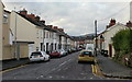
Crown Street, Newport
Heading away from Victoria Avenue towards Albert Avenue and the Crown Inn.
Image: © Jaggery
Taken: 1 Nov 2009
0.03 miles
2
Victoria Avenue, Newport
Heading away from Chepstow Road towards Summerhill Avenue and Christchurch Road.
Image: © Jaggery
Taken: 1 Nov 2009
0.04 miles
3
Albert Court, Victoria Avenue, Newport
A group of modern houses on the west side of Victoria Avenue, near the Crown Street junction.
Image: © Jaggery
Taken: 1 Nov 2009
0.04 miles
4
Crown Street from Albert Avenue, Maindee, Newport
Looking towards Victoria Avenue. On the left is The Crown Inn. http://www.geograph.org.uk/photo/1735993
Image: © Jaggery
Taken: 4 Mar 2010
0.04 miles
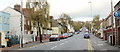
5
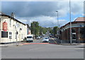
Victoria Avenue, Newport
Victoria Avenue climbs away from Chepstow Road towards Christchurch Road, past
The George http://www.geograph.org.uk/photo/2984804 on the left and a branch of Barclays bank on the right. http://www.geograph.org.uk/photo/1452171
Image: © Jaggery
Taken: 9 Jun 2012
0.04 miles
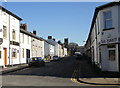
6
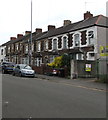
Row of stone houses, Victoria Avenue, Newport
In the Maindee area of Newport.
Image: © Jaggery
Taken: 6 Jun 2020
0.04 miles
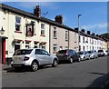
7
Albert Avenue, Maindee, Newport
Viewed from the corner of Maindee Square in early June 2020. The Royal Albert pub on the left https://www.geograph.org.uk/photo/6499808 has been closed since late March 2020 during the nationwide Coronavirus (COVID-19) pandemic lockdown.
Image: © Jaggery
Taken: 6 Jun 2020
0.05 miles
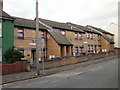
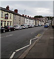
8
Cars, houses and a pub, Albert Avenue, Maindee, Newport
The west side of Albert Avenue viewed from Maindee Square in late May 2018.
The Royal Albert is on the left.
Image: © Jaggery
Taken: 22 May 2018
0.06 miles
9
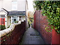
Victoria Lane, Newport
Viewed from Victoria Avenue, the lane heads towards Kensington Place.
Image: © Jaggery
Taken: 1 Nov 2009
0.07 miles
10
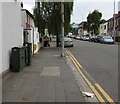
Dark green cabinets, Victoria Avenue, Newport
Telecoms cabinets on the west side of Victoria Avenue in the Maindee area of Newport.
The cabinet near the camera is numbered 61.
Image: © Jaggery
Taken: 6 Jun 2020
0.07 miles