IMAGES TAKEN NEAR TO
Chepstow Road, NEWPORT, NP19 8EA
Introduction
This page details the photographs taken nearby to Chepstow Road, NP19 8EA by members of the Geograph project.
The Geograph project started in 2005 with the aim of publishing, organising and preserving representative images for every square kilometre of Great Britain, Ireland and the Isle of Man.

There are currently over 7.5m images from over14,400 individuals and you can help contribute to the project by visiting https://www.geograph.org.uk
Image Map
Images are licensed for reuse under creativecommons.org/licenses/by-sa/2.0
Notes
- Clicking on the map will re-center to the selected point.
- The higher the marker number, the further away the image location is from the centre of the postcode.
Image Listing (858 Images Found)
Images are licensed for reuse under creativecommons.org/licenses/by-sa/2.0
Image
Details
Distance
1
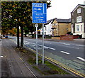
Part-time bus lane, Chepstow Road, Newport
The lane on the south side of Chepstow Road is for vehicles travelling towards the city centre.
The lane is reserved for buses, coaches, taxis, motorbikes and bicycles between
7am-10am and 3.30pm-6.30pm Mondays-Fridays. Llun-Gwe is Welsh for Mon-Fri.
Image: © Jaggery
Taken: 25 Sep 2017
0.02 miles
2
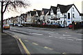
East along Chepstow Road, Newport
Chepstow Road heads away from Clarence Place (100 metres behind the camera).
The Dodger pub http://www.geograph.org.uk/photo/4772153 is on the right.
Image: © Jaggery
Taken: 23 Dec 2015
0.02 miles
3
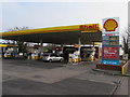
January 19th 2017 fuel prices at the Shell filling station, Chepstow Road, Newport
Unleaded regular petrol is 119.9 pence per litre. Regular diesel is 123.9 pence per litre.
Image: © Jaggery
Taken: 19 Jan 2017
0.02 miles
4
Chepstow Road Shell fuel prices in late December 2015, Newport
On December 23rd 2015, unleaded regular petrol is 103.9 pence per litre and regular diesel 107.9 pence.
Prices are a few pence lower at other filling stations in the area.
The lowest I've seen is 99.9 pence per litre for petrol at two filling stations in Cwmbran.
Image: © Jaggery
Taken: 23 Dec 2015
0.02 miles
5
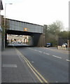
Two-thirds of the Maindee Triangle, Newport
Two railway bridges across Caerleon Road are part of a triangular section of interconnected lines known as the Maindee Triangle. The nearer bridge carries the South Wales to London main line. The distant bridge http://www.geograph.org.uk/photo/1943514 carries a line connecting the line to Cwmbran and The North with the eastern side of the South Wales to London line, which gives the option of avoiding Newport railway station.
http://www.geograph.org.uk/photo/1671050 for the third bridge and an explanation of a railway triangle.
Image: © Jaggery
Taken: 11 Apr 2010
0.02 miles
6
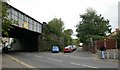
Sheaf Lane, Newport
Viewed across Caerleon Road, Sheaf Lane runs between the southern edge of the Maindee Triangle. http://www.geograph.org.uk/photo/1800610 and the northern edge of the car park of the Tax Office.http://www.geograph.org.uk/photo/1646088
Image: © Jaggery
Taken: 6 Sep 2009
0.02 miles
7
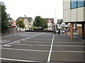
Parking bays and brick stilts, Newport Tax Office
Looking from Caerleon Road towards Chepstow Road across the numbered parking bays adjacent to the tax office. http://www.geograph.org.uk/photo/1646088
At the right of the photo are two of the brick stilts or pillars that support part of the tax office building.
Image: © Jaggery
Taken: 6 Sep 2009
0.02 miles
8
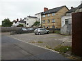
Parking area, Sheaf Lane, Newport
There are no houses on Sheaf Lane,http://www.geograph.org.uk/photo/1943427, a short lane on the east side of Caerleon Road. The houses seen here are on Chepstow Road. The only use of the lane nowadays, it seems, is as a parking area.
Image: © Jaggery
Taken: 11 Jul 2010
0.02 miles
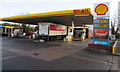
9
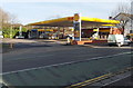
Shell garage and shop, Chepstow Road, Newport
Located at 17-25 Chepstow Road.
Image: © Jaggery
Taken: 9 Jan 2013
0.02 miles
10
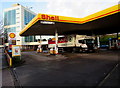
Spar lorry in the Shell service station, Chepstow Road, Newport
The lorry has brought stock for the Spar shop out shot on the right.
Image: © Jaggery
Taken: 23 Dec 2015
0.02 miles