IMAGES TAKEN NEAR TO
Prince Street, NEWPORT, NP19 8DS
Introduction
This page details the photographs taken nearby to Prince Street, NP19 8DS by members of the Geograph project.
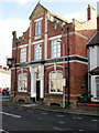
The Geograph project started in 2005 with the aim of publishing, organising and preserving representative images for every square kilometre of Great Britain, Ireland and the Isle of Man.

There are currently over 7.5m images from over14,400 individuals and you can help contribute to the project by visiting https://www.geograph.org.uk
Image Map
Images are licensed for reuse under creativecommons.org/licenses/by-sa/2.0
Notes
- Clicking on the map will re-center to the selected point.
- The higher the marker number, the further away the image location is from the centre of the postcode.
Image Listing (838 Images Found)
Images are licensed for reuse under creativecommons.org/licenses/by-sa/2.0
Image
Details
Distance
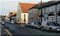
1
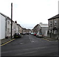
Prince Street towards Barnardtown, Newport
From Hereford Street in the Maindee area of Newport,
Prince Street leads to the Barnardtown area of Newport.
Image: © Jaggery
Taken: 6 Jun 2020
0.01 miles
2
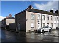
Corner of Prince Street and Manchester Street, Newport
If this tiny March 2017 sample is typical, satellite dishes are not optimally placed on rooftops, unlike TV aerials.
Image: © Jaggery
Taken: 21 Mar 2017
0.02 miles
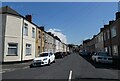
3
West along Manchester Street, Newport
Viewed from the corner of Hereford Street looking along Manchester Street
towards Prince Street in the Barnardtown area of Newport.
Image: © Jaggery
Taken: 15 Sep 2016
0.02 miles
4
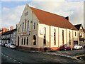
A2Z Computing, Hereford Street, Newport
Located on the corner of Hereford Street and Exeter Street. Current occupiers are A2Z Computing Ltd.
The Bible Christians, or United Methodists, opened a mission chapel here in 1893. Kelly's 1901 Directory records the premises as "Bible Christian Chapel" and later it was known as Hereford Street Methodist Church. It continued in use as a chapel until the early 1960s when it was sold to become a tyre sales depot.
Image: © Jaggery
Taken: 3 Dec 2009
0.02 miles
5
Hereford Street, Newport
Looking along the east side of Hereford Street. On the right, at the corner of Exeter Street, is a former Methodist chapel http://www.geograph.org.uk/photo/1605352 now used as a computing company premises.
Image: © Jaggery
Taken: 3 Dec 2009
0.02 miles
6
Hereford Arms, Newport
On the corner of Hereford Street and Liverpool Street. Their website describes the pub as
" ... Newport's premier biker pub. Darts, pool, a well stocked jukebox and great beer. Stop over accommodation is available on request."
UPDATE March 2013 The pub is closed, boarded up and to let. http://www.geograph.org.uk/photo/3352492
Image: © Jaggery
Taken: 3 Dec 2009
0.02 miles
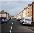
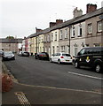
8
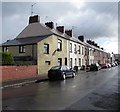
Prince Street houses, Newport
Row of Prince Street houses between Manchester Street and Hereford Street (ahead).
Image: © Jaggery
Taken: 21 Mar 2017
0.03 miles
9
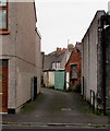
Lane to Princes Mews, Newport
From Prince Street the lane leads to numbers 1-5 Princes Mews out of shot ahead.
Image: © Jaggery
Taken: 18 Nov 2017
0.03 miles
10
West along Bristol Street, Newport
Bristol Street from the corner of Hereford Street towards Whitby Place.
Image: © Jaggery
Taken: 30 May 2019
0.04 miles