IMAGES TAKEN NEAR TO
Whitby Place, NEWPORT, NP19 8DQ
Introduction
This page details the photographs taken nearby to Whitby Place, NP19 8DQ by members of the Geograph project.
The Geograph project started in 2005 with the aim of publishing, organising and preserving representative images for every square kilometre of Great Britain, Ireland and the Isle of Man.

There are currently over 7.5m images from over14,400 individuals and you can help contribute to the project by visiting https://www.geograph.org.uk
Image Map
Images are licensed for reuse under creativecommons.org/licenses/by-sa/2.0
Notes
- Clicking on the map will re-center to the selected point.
- The higher the marker number, the further away the image location is from the centre of the postcode.
Image Listing (833 Images Found)
Images are licensed for reuse under creativecommons.org/licenses/by-sa/2.0
Image
Details
Distance
1
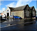
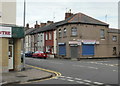
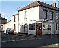
John Phillips Auto Engineers, Newport
An accredited Autosafe Centre located at 1 Whitby Place in a former church building. From 1871 until about 1900, this was a Wesleyan Methodist chapel. The congregation outgrew the premises, so a new church http://www.geograph.org.uk/photo/1426314 was built a few hundred metres away. The Methodists moved there in 1902.
Image: © Jaggery
Taken: 21 Mar 2017
0.01 miles
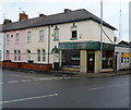
2
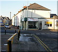
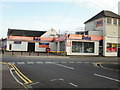
The Piano Centre, Newport
Located on the corner of Church Road and Gloster Place.
UPDATE February 2012. The premises are now occupied by a tattoo studio. http://www.geograph.org.uk/photo/2798936
Image: © Jaggery
Taken: 4 Jan 2010
0.01 miles
3
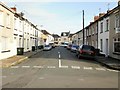
Alfred Street, Newport
Viewed from the Junction Road end looking towards Church Road.
Image: © Jaggery
Taken: 6 Sep 2009
0.01 miles
4
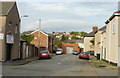
Short eastern arm of Whitby Place, Newport
Whitby Place is cut in two by Prince Street. The western arm is about twice the length of the eastern arm seen here. Near the far end of the view is the right turn for Camelot Place and Bristol Street.
Image: © Jaggery
Taken: 6 Sep 2009
0.01 miles
5
Consumables2Go, Barnardtown, Newport
Computer store and repair centre on the corner of Church Road and Prince Street. The premises were previously occupied by AJM Micro, which ran a similar business.
Image: © Jaggery
Taken: 11 Jul 2010
0.01 miles
6
Former Data premises, Barnardtown, Newport
Located on the corner of Church Road and Prince Street, at the date of this photo, September 2009, the premises were occupied by Data, tool sales, repairs and spares. A photo taken in July 2010 http://www.geograph.org.uk/photo/1958256 shows new occupiers and a more restrained colour scheme.
Image: © Jaggery
Taken: 6 Sep 2009
0.01 miles
7
C&S, uPVC Decor Centre, Barnardtown, Newport
A new occupier and different colour scheme for these premises on the corner of Church Road and Prince Street in the Barnardtown area of Newport. The previous occupiers were Data tools. http://www.geograph.org.uk/photo/1958253
Image: © Jaggery
Taken: 11 Jul 2010
0.01 miles
8
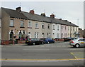
Gloster Place, Newport
Houses on the east side of Gloster Place, a short street between Caerleon Road and Church Road.
At the far end of the street, on the corner of Church Road, is The Piano Centre.http://www.geograph.org.uk/photo/1646145
Image: © Jaggery
Taken: 11 Jul 2010
0.01 miles
9
The Busy Kitchen, Newport
Cafe and takeaway located on the corner of Church Road and Alfred Street.
Image: © Jaggery
Taken: 29 Aug 2010
0.01 miles
10
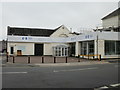
The Point Custom Tattoo Studio, Newport
Occupying premises on the corner of Gloster Place and Church Road formerly occupied by The Piano Centre. http://www.geograph.org.uk/photo/1646145
Image: © Jaggery
Taken: 5 Feb 2012
0.01 miles