IMAGES TAKEN NEAR TO
Glanmor Park Avenue, NEWPORT, NP19 8BA
Introduction
This page details the photographs taken nearby to Glanmor Park Avenue, NP19 8BA by members of the Geograph project.
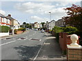
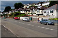
The Geograph project started in 2005 with the aim of publishing, organising and preserving representative images for every square kilometre of Great Britain, Ireland and the Isle of Man.

There are currently over 7.5m images from over14,400 individuals and you can help contribute to the project by visiting https://www.geograph.org.uk
Image Map
Images are licensed for reuse under creativecommons.org/licenses/by-sa/2.0
Notes
- Clicking on the map will re-center to the selected point.
- The higher the marker number, the further away the image location is from the centre of the postcode.
Image Listing (110 Images Found)
Images are licensed for reuse under creativecommons.org/licenses/by-sa/2.0
Image
Details
Distance
1
Christchurch Road approaching the post office
Looking east along Christchurch Road. The post office http://www.geograph.org.uk/photo/1720216 is on the right in the middle distance.
Image: © Jaggery
Taken: 24 Sep 2009
0.10 miles
2
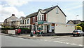
Christchurch Road post office, Newport
Post office, newsagents and general store, located on the corner of Christchurch Road and Gibbs Road.
Image: © Jaggery
Taken: 24 Sep 2009
0.10 miles
3
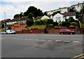
Penylan Baptist Church, Newport
Set back about 20 metres from the south side of Christchurch Road.
Summerhill Baptist Chapel established the Penylan Mission here in 1903 to replace house meetings in the area. The small rectangular building doubles as a worship centre and hall for social activities.
Image: © Jaggery
Taken: 24 Sep 2009
0.10 miles
4
Chepstow Road bungalows, Newport
Bungalows above the north side of Chepstow Road viewed from the corner of Aberthaw Road.
The two-storey houses in the background are on the south side of Lawrence Hill Avenue.
Image: © Jaggery
Taken: 2 Jul 2016
0.12 miles
5
Bungalows above Chepstow Road, Newport
Derived from a Hindi word meaning in the style of Bengal, bungalow was originally used in English for a lightly-built house, with a veranda and one storey. In current UK usage it is a convenient word for any one-storey dwelling.
Image: © Jaggery
Taken: 21 Jun 2019
0.12 miles
6
Bungalows above Chepstow Road, Newport
Above the north side of Chepstow Road viewed from the corner of Aberthaw Road.
The two-storey houses in the background are on the south side of Lawrence Hill Avenue.
Image: © Jaggery
Taken: 2 Jul 2016
0.13 miles
7
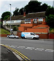
Polygon leak detection van, Chepstow Road, Newport
Parked opposite the Aberthaw Road junction.
Polygon UK is based in Blackstone Road, Huntingdon, Cambridgeshire.
Image: © Jaggery
Taken: 2 Jul 2016
0.13 miles
8

Junction of Chepstow Road and Aberthaw Road, Newport
Aberthaw Road from the left joins Chepstow Road. A sign near the van
on the right points along Aberthaw Road towards the Alway area of Newport.
Image: © Jaggery
Taken: 2 Jul 2016
0.13 miles
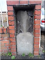
9
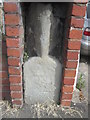
Milestone - Newport 2
There is an OS cut mark on the base of this milestone. It marks a point 26.359m above mean sea level.
Image: © Adrian Dust
Taken: 25 May 2015
0.14 miles
10
Old Milestone by the B4237 in Newport
This old weathered milestone has been built into the gate pillar for #555 Chepstow Road, on the north side of the road.
Inscription once read:- : (Newport 2 / Chepstow 14) :
Carved bench mark on lower face.
Milestone Society National ID: MON_CWNP14
Image: © Kirstie Hackett
Taken: 8 Mar 2015
0.14 miles