IMAGES TAKEN NEAR TO
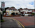
Lawrence Hill, NEWPORT, NP19 8AY
Introduction
This page details the photographs taken nearby to Lawrence Hill, NP19 8AY by members of the Geograph project.
The Geograph project started in 2005 with the aim of publishing, organising and preserving representative images for every square kilometre of Great Britain, Ireland and the Isle of Man.

There are currently over 7.5m images from over14,400 individuals and you can help contribute to the project by visiting https://www.geograph.org.uk
Image Map
Images are licensed for reuse under creativecommons.org/licenses/by-sa/2.0
Notes
- Clicking on the map will re-center to the selected point.
- The higher the marker number, the further away the image location is from the centre of the postcode.
Image Listing (213 Images Found)
Images are licensed for reuse under creativecommons.org/licenses/by-sa/2.0
Image
Details
Distance
1
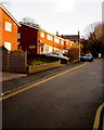
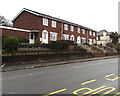
Lawrence Hill houses, Newport
Lawrence Hill is a steep cul-de-sac connecting with Chepstow Road behind the camera.
Image: © Jaggery
Taken: 23 Dec 2015
0.02 miles
2
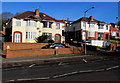
Semi-detached houses, Chepstow Road, Newport
Viewed from the corner of Hawthorn Avenue.
Image: © Jaggery
Taken: 16 Feb 2016
0.03 miles
3
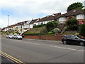
Bungalows above Chepstow Road, Newport
Buildings on the camera side are set at road level whereas the bungalows on the north side of Chepstow Road are set several metres higher, accessed by steps. They are at the edge of steeply sloping land towards the Christchurch area of Newport.
Image: © Jaggery
Taken: 2 Jul 2016
0.03 miles
4
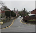
Up Lawrence Hill, Newport
Dead-end Lawrence Hill ascends from Chepstow Road.
Image: © Jaggery
Taken: 5 Mar 2020
0.03 miles
5

Row of brick houses on the north side of Chepstow Road, Newport
A few metres east of the Lawrence Hill junction.
Image: © Jaggery
Taken: 2 Jul 2016
0.03 miles
6
Row of brick houses above Chepstow Road, Newport
The house on the left is on the corner of Lawrence Hill.
Image: © Jaggery
Taken: 5 Mar 2020
0.03 miles
7
Pelican crossing, Chepstow Road, Newport
Across the B4237 Chepstow Road near Acacia Avenue and Hawthorn Avenue.
Chambers Dictionary states that "pelican" is adapted from "pedestrian light controlled crossing".
Image: © Jaggery
Taken: 23 Dec 2015
0.04 miles
8
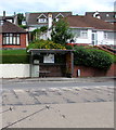
Chepstow Road bus stop and shelter, Newport
On the north side of Chepstow Road near Acacia Avenue and Somerton Crescent.
Image: © Jaggery
Taken: 2 Jul 2016
0.04 miles
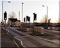
9
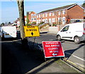
Temporary signs on a Chepstow Road corner, Newport
On the corner of Hawthorn Avenue, facing westbound traffic on the B4237 Chepstow Road on the approach to the Somerton Road junction. Viewed in February 2016, when Somerton Road is temporarily not a through road while work is in progress on rebuilding the bridge over the South Wales main line in preparation for the electrification of the railway route later this decade.
Image: © Jaggery
Taken: 16 Feb 2016
0.04 miles
10
Junction of Hawthorn Avenue and Chepstow Road, Newport
The 20mph speed limit on Hawthorn Avenue increases to 30mph on Chepstow Road.
Image: © Jaggery
Taken: 2 Jul 2016
0.04 miles