IMAGES TAKEN NEAR TO
Hertford Place, NEWPORT, NP19 7SN
Introduction
This page details the photographs taken nearby to Hertford Place, NP19 7SN by members of the Geograph project.
The Geograph project started in 2005 with the aim of publishing, organising and preserving representative images for every square kilometre of Great Britain, Ireland and the Isle of Man.

There are currently over 7.5m images from over14,400 individuals and you can help contribute to the project by visiting https://www.geograph.org.uk
Image Map
Images are licensed for reuse under creativecommons.org/licenses/by-sa/2.0
Notes
- Clicking on the map will re-center to the selected point.
- The higher the marker number, the further away the image location is from the centre of the postcode.
Image Listing (120 Images Found)
Images are licensed for reuse under creativecommons.org/licenses/by-sa/2.0
Image
Details
Distance
1
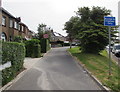
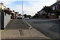
Access to Premises Only sign, Buckingham Crescent, Newport
Facing Christchurch Road at the western end of Buckingham Crescent. http://www.geograph.org.uk/photo/1739365
Image: © Jaggery
Taken: 10 Jun 2016
0.04 miles
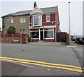
2
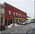
Beechwood Stores, Newport
Premier convenience store at 88 Christchurch Road.
Image: © Jaggery
Taken: 10 Jun 2016
0.04 miles
3
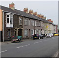
Long row of houses, Christchurch Road, Newport
Extending for 70 metres towards Beechwood Stores. http://www.geograph.org.uk/photo/4992039
Image: © Jaggery
Taken: 10 Jun 2016
0.04 miles
4
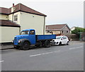
Old-style Ford Thames lorry, Christchurch Road, Newport
Dating from c1955, the blue lorry is parked near Beechwood Stores, on the right here. http://www.geograph.org.uk/photo/4992039
Image: © Jaggery
Taken: 10 Jun 2016
0.04 miles
5
Southern end of Norfolk Road, Newport
Looking north along Norfolk Road from the corner of Christchurch Road.
Image: © Jaggery
Taken: 7 Aug 2018
0.04 miles
6
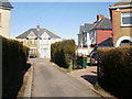
Buckingham Place, Newport
A very short street bearing north from the midpoint of Buckingham Crescent. http://www.geograph.org.uk/photo/1739365
Image: © Jaggery
Taken: 4 Mar 2010
0.05 miles
7
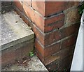
Ordnance Survey Cut Mark
This OS cut mark can be found on No96 St Julians Road. It marks a point 54.489m above mean sea level.
Image: © Adrian Dust
Taken: 9 Jun 2018
0.05 miles
8

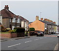
Buckingham Crescent, Newport
On the north side of, and slightly above, Christchurch Road.
http://www.geograph.org.uk/photo/1739365 to a wider view of Buckingham Crescent.
Image: © Jaggery
Taken: 10 Jun 2016
0.05 miles
9
Change of house type, Christchurch Road, Newport
Looking west along Christchurch Road from the corner of Buckingham Crescent.
Image: © Jaggery
Taken: 10 Jun 2016
0.06 miles
10
Liberte Hair Care, Newport
Christchurch Road hair salon on the corner of Norfolk Road.
Image: © Jaggery
Taken: 10 Jun 2016
0.06 miles