IMAGES TAKEN NEAR TO
Vandyke Close, NEWPORT, NP19 7QZ
Introduction
This page details the photographs taken nearby to Vandyke Close, NP19 7QZ by members of the Geograph project.
The Geograph project started in 2005 with the aim of publishing, organising and preserving representative images for every square kilometre of Great Britain, Ireland and the Isle of Man.

There are currently over 7.5m images from over14,400 individuals and you can help contribute to the project by visiting https://www.geograph.org.uk
Image Map
Images are licensed for reuse under creativecommons.org/licenses/by-sa/2.0
Notes
- Clicking on the map will re-center to the selected point.
- The higher the marker number, the further away the image location is from the centre of the postcode.
Image Listing (64 Images Found)
Images are licensed for reuse under creativecommons.org/licenses/by-sa/2.0
Image
Details
Distance
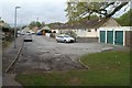
1
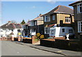
Hogarth Close, Newport
Houses on the north side of Hogarth Close are set about a metre below the level of the pavement. On the far side of the houses, behind screening trees, is the M4 motorway. This view is from the corner of Rembrandt Way.
Image: © Jaggery
Taken: 7 Feb 2010
0.04 miles
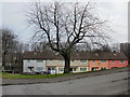
2
Rembrandt Way, Newport
Viewed from the corner of Heather Road.
Image: © Jaggery
Taken: 24 Sep 2009
0.06 miles
3
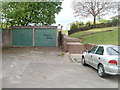
Steps to Rembrandt Way, Newport
There is no vehicular access at the western end of Constable Drive. Pedestrians can use the steps to Rembrandt Way.
Image: © Jaggery
Taken: 14 Apr 2011
0.08 miles
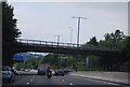
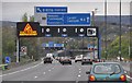
5
M4 Motorway - Rembrandt Way overbridge, Newport
Image: © J Whatley
Taken: 22 Sep 2010
0.10 miles
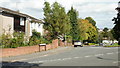
6
Elaine Crescent (2), St Julians, Newport
The western end and eastern end of Elaine Crescent connect with Heather Road.
The ends are about 100 metres apart. This view is of houses at the eastern end, viewed from Heather Road.
Image: © Jaggery
Taken: 4 Mar 2010
0.10 miles
7
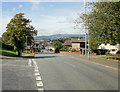
Looking down Heather Road, Newport
On the left is Merlin Crescent; on the right is Rembrandt Way. http://www.geograph.org.uk/photo/1720201
Just visible in the middle of the high ground in the far distance is Twmbarlwm Image
Image: © Jaggery
Taken: 24 Sep 2009
0.10 miles
8
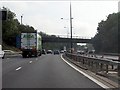
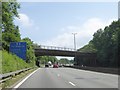
Newport : The M4 Motorway
The M4 Motorway heading through the Newport area of Wales.
Image: © Lewis Clarke
Taken: 10 Apr 2014
0.11 miles
10
Hogarth Close, Newport
The view from near the edge of a footpath http://www.geograph.org.uk/photo/2357329 leading to a motorway underpass.
Image: © Jaggery
Taken: 14 Apr 2011
0.11 miles