IMAGES TAKEN NEAR TO
Brangwyn Crescent, NEWPORT, NP19 7QY
Introduction
This page details the photographs taken nearby to Brangwyn Crescent, NP19 7QY by members of the Geograph project.
The Geograph project started in 2005 with the aim of publishing, organising and preserving representative images for every square kilometre of Great Britain, Ireland and the Isle of Man.

There are currently over 7.5m images from over14,400 individuals and you can help contribute to the project by visiting https://www.geograph.org.uk
Image Map
Images are licensed for reuse under creativecommons.org/licenses/by-sa/2.0
Notes
- Clicking on the map will re-center to the selected point.
- The higher the marker number, the further away the image location is from the centre of the postcode.
Image Listing (67 Images Found)
Images are licensed for reuse under creativecommons.org/licenses/by-sa/2.0
Image
Details
Distance
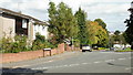
1
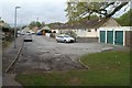
Hogarth Close, Newport
The view from near the edge of a footpath http://www.geograph.org.uk/photo/2357329 leading to a motorway underpass.
Image: © Jaggery
Taken: 14 Apr 2011
0.01 miles
2
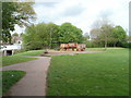
Children's play area opposite Hogarth Close, Newport
The play area is on a strip of greenery on the south side of the M4 motorway, next to a path leading to an underpass, visible at the left edge of the view.
Image: © Jaggery
Taken: 14 Apr 2011
0.05 miles
3
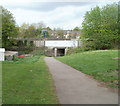
Path to motorway underpass near Hogarth Close, Newport
A path heads under the M4 motorway towards the south side of Constable Drive.
Image: © Jaggery
Taken: 14 Apr 2011
0.05 miles
4
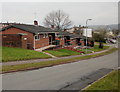
Bungalows, Brangwyn Crescent, Newport
Bungalows with orange-topped wheelie bins neatly arranged outside each one.
Near the Heather Road end of Brangwyn Crescent.
Image: © Jaggery
Taken: 7 Feb 2010
0.06 miles
5
Rembrandt Way, Newport
Viewed from the corner of Heather Road.
Image: © Jaggery
Taken: 24 Sep 2009
0.07 miles
6
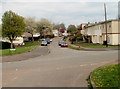
Kelly Road, Newport
Viewed from the corner of Brangwyn Crescent.
Image: © Jaggery
Taken: 14 Apr 2011
0.08 miles
7
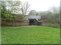
Motorway underpass, Constable Drive, Newport
A path leads from Constable Drive to an underpass beneath the M4 motorway.
Image: © Jaggery
Taken: 14 Apr 2011
0.08 miles
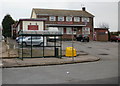
8
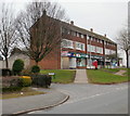
St Julians post office, Newport
At 86 Heather Road, in a block of shops that includes, from left to right :
An empty property, formerly Coral bookmakers.
St Julians post office.
Beauty Salon.
Heather Stores.
Image: © Jaggery
Taken: 7 Feb 2010
0.09 miles
9
The Centurion, St Julians, Newport
Pub on Heather Road, adjacent to the block of shops. http://www.geograph.org.uk/photo/1703764
Image: © Jaggery
Taken: 7 Feb 2010
0.09 miles
10
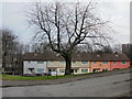
Hogarth Close, Newport
Houses on the north side of Hogarth Close are set about a metre below the level of the pavement. On the far side of the houses, behind screening trees, is the M4 motorway. This view is from the corner of Rembrandt Way.
Image: © Jaggery
Taken: 7 Feb 2010
0.10 miles