IMAGES TAKEN NEAR TO
Christchurch Road, NEWPORT, NP19 7QN
Introduction
This page details the photographs taken nearby to Christchurch Road, NP19 7QN by members of the Geograph project.
The Geograph project started in 2005 with the aim of publishing, organising and preserving representative images for every square kilometre of Great Britain, Ireland and the Isle of Man.

There are currently over 7.5m images from over14,400 individuals and you can help contribute to the project by visiting https://www.geograph.org.uk
Image Map
Images are licensed for reuse under creativecommons.org/licenses/by-sa/2.0
Notes
- Clicking on the map will re-center to the selected point.
- The higher the marker number, the further away the image location is from the centre of the postcode.
Image Listing (77 Images Found)
Images are licensed for reuse under creativecommons.org/licenses/by-sa/2.0
Image
Details
Distance
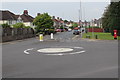
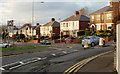
1
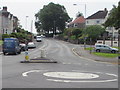
Christchurch Road towards Beechwood Park, Newport
Viewed across the mini-roundabout at the St Julians Road junction looking along Christchurch Road towards the tree in the NW corner of Beechwood Park. The Clevedon Road junction is behind the car on the right.
Image: © Jaggery
Taken: 10 Jun 2016
0.02 miles
2
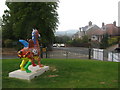
Dragon and Christchurch Road
SuperDragon sculpture 'Graffiti' looking west over Christchurch Road by its junction with Clevedon Road towards distant Twm Barlwm mountain.
Image: © David Roberts
Taken: 9 Sep 2010
0.03 miles
3
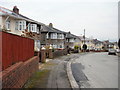
Firbank Crescent, Newport
Houses on the south side of Firbank Crescent, viewed from the corner of Hove Avenue.
Image: © Jaggery
Taken: 7 Feb 2010
0.04 miles
4
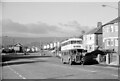
The top of St Julian's Road, Newport ? 1968
Not greatly different 40 years on https://www.geograph.org.uk/photo/1566517 – the trees have grown and the road layout has been adjusted to include a mini-roundabout.
The bus is Newport Corporation no.56, a Leyland Titan with bodywork by the small Bristol-based firm Longwell Green, whose 'trademark' was the distinctive curve to the canopy over the driver's cab.
This is one of a series of views featuring buses in the 60s, 70s, and 80s.
http://www.geograph.org.uk/search.php?i=2114547&displayclass=slide
Image: © Alan Murray-Rust
Taken: 2 Jan 1968
0.06 miles
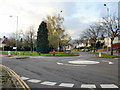
5
Mini-roundabout at the SE end of St Julians Road, Newport
St Julians Road from the right joins Christchurch Road.
Image: © Jaggery
Taken: 10 Jun 2016
0.08 miles
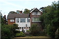
6
Woodland Park Road, Beechwood
Eastern end of road just below junction with Clevedon Road.
Image: © M J Roscoe
Taken: 21 Sep 2019
0.09 miles
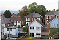
7
Rear of house, Clevedon Road, Beechwood
Detached house on west side of road.
Image: © M J Roscoe
Taken: 21 Sep 2019
0.09 miles
8
St Julians mini-roundabout, Newport
To the left is Christchurch Road ; to the right is St Julians Road. Closeup of the George V postbox http://www.geograph.org.uk/photo/1566514
Image: © Jaggery
Taken: 1 Nov 2009
0.10 miles
9
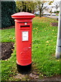
George V postbox, St Julians, Newport
Located at the junction of Christchurch Road and St Julians Road. http://www.geograph.org.uk/photo/1566517
Image: © Jaggery
Taken: 1 Nov 2009
0.10 miles
10
Humps for 780 yards, Christchurch Road, Newport
The sign on the left announces humps for 780 yards if you turn right into Christchurch Road, whereas there are only 20 yards of humps if you turn left into St Julians Road. The view is from Clevedon Road.
A curiosity is that adjacent houses viewed here are numbered 153, 155, 147, 149. The explanation is that 153 and 155 are at the end of St Julians Road. Christchurch Road, which began at the junction of Duckpool Road, now resumes at 147 after a short break at 145 about 50 metres away.
Image: © Jaggery
Taken: 1 Nov 2009
0.10 miles