IMAGES TAKEN NEAR TO
Munnings Drive, NEWPORT, NP19 7PD
Introduction
This page details the photographs taken nearby to Munnings Drive, NP19 7PD by members of the Geograph project.
The Geograph project started in 2005 with the aim of publishing, organising and preserving representative images for every square kilometre of Great Britain, Ireland and the Isle of Man.

There are currently over 7.5m images from over14,400 individuals and you can help contribute to the project by visiting https://www.geograph.org.uk
Image Map
Images are licensed for reuse under creativecommons.org/licenses/by-sa/2.0
Notes
- Clicking on the map will re-center to the selected point.
- The higher the marker number, the further away the image location is from the centre of the postcode.
Image Listing (39 Images Found)
Images are licensed for reuse under creativecommons.org/licenses/by-sa/2.0
Image
Details
Distance
1
Holbein Road, St Julians, Newport
Viewed from Beaufort Road.
Image: © Jaggery
Taken: 20 Aug 2009
0.06 miles
2
Wilson Road, St Julians , Newport
Viewed from Beaufort Road.
Image: © Jaggery
Taken: 20 Aug 2009
0.06 miles
3
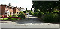
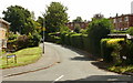
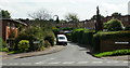
Munnings Drive, St Julians, Newport
This view is of the northern end of Munnings Drive, seen from Beaufort Road.
Image: © Jaggery
Taken: 20 Aug 2009
0.06 miles
4
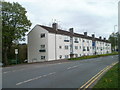
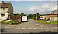
Beaufort Road flats, Newport
A block of 18 flats on the east side of Beaufort Road, viewed from opposite the Renoir Road turning.
Image: © Jaggery
Taken: 14 Apr 2011
0.07 miles
5
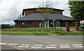
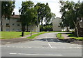
Beaufort Community Centre, St Julians, Newport
Located on Beaufort Road, close to St Julians Junior School. It is one of 22 community centres and halls in the city of Newport, for use by local groups and individuals. Community centres have a wide range of activities for adults and children including fitness classes and after-school clubs. The activities of the Centres are overseen by the Community Centre Coordinator, Newport City Council.
Image: © Jaggery
Taken: 20 Aug 2009
0.11 miles
6
Flint Close, St Julians, Newport
Flint Close, viewed here from Beaufort Road, heads northwestwards and ends at the edge of the St Julians Junior School playing fields. http://www.geograph.org.uk/photo/1566544
Image: © Jaggery
Taken: 20 Aug 2009
0.12 miles
7
Cotman Close, St Julians, Newport
Viewed from Beaufort Road. Cotman Close ends at the south-west corner of the St Julians Junior School playing fields.
Image: © Jaggery
Taken: 20 Aug 2009
0.12 miles
8
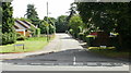
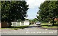
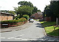
Steer Crescent, St Julians, Newport
Viewed from Beaufort Road, Steer Crescent heads towards Munnings Drive.
Image: © Jaggery
Taken: 20 Aug 2009
0.15 miles
9
Monet Crescent, St Julians, Newport
Viewed from Beaufort Road, Monet Crescent heads towards Munnings Drive.
Image: © Jaggery
Taken: 20 Aug 2009
0.15 miles
10
Sutherland Crescent, St Julians, Newport
Viewed from Beaufort Road, Sutherland Crescent heads towards Munnings Drive.
Image: © Jaggery
Taken: 20 Aug 2009
0.15 miles