IMAGES TAKEN NEAR TO
Gainsborough Drive, NEWPORT, NP19 7NW
Introduction
This page details the photographs taken nearby to Gainsborough Drive, NP19 7NW by members of the Geograph project.
The Geograph project started in 2005 with the aim of publishing, organising and preserving representative images for every square kilometre of Great Britain, Ireland and the Isle of Man.

There are currently over 7.5m images from over14,400 individuals and you can help contribute to the project by visiting https://www.geograph.org.uk
Image Map
Images are licensed for reuse under creativecommons.org/licenses/by-sa/2.0
Notes
- Clicking on the map will re-center to the selected point.
- The higher the marker number, the further away the image location is from the centre of the postcode.
Image Listing (46 Images Found)
Images are licensed for reuse under creativecommons.org/licenses/by-sa/2.0
Image
Details
Distance

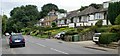
2
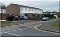
Augustus John Close, Newport
Houses on the north side of the street, viewed from Monmouth Drive.
Many streets in this area are named after artists. Augustus John (1878-1961) was a Welsh artist famous for his figure drawings, and for a new technique of oil sketching. His work was favourably compared in London with that of Matisse and Gauguin.
Image: © Jaggery
Taken: 14 Apr 2011
0.08 miles
3
An entrance to St Julians Junior School, Newport
Viewed from Beaufort Road.
Image: © Jaggery
Taken: 31 Dec 2009
0.10 miles
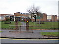
5
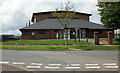
Beaufort Community Centre, St Julians, Newport
Located on Beaufort Road, close to St Julians Junior School. It is one of 22 community centres and halls in the city of Newport, for use by local groups and individuals. Community centres have a wide range of activities for adults and children including fitness classes and after-school clubs. The activities of the Centres are overseen by the Community Centre Coordinator, Newport City Council.
Image: © Jaggery
Taken: 20 Aug 2009
0.11 miles
6
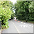
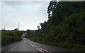
Caerleon Road woods, Newport
Heading towards Caerleon, Caerleon Road here passes through a small wooded area. The road gives little clue to the steepness of the contours here - on the left, there is a drop of several metres to the River Usk; on the right, the land rises steeply away from the road towards the heights of Christchurch.
Image: © Jaggery
Taken: 23 Aug 2009
0.11 miles
7
Caerleon Road approaching wooded area, Newport
Houses and bungalows on the south side of Caerleon Road as it approaches a wooded area http://www.geograph.org.uk/photo/1590669 alongside the River Usk
Image: © Jaggery
Taken: 23 Aug 2009
0.12 miles
8
St Julians Junior School, Newport
On the south side of Beaufort Road, the school grounds are below the level of the road.
Image: © Jaggery
Taken: 20 Aug 2009
0.12 miles
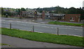
9
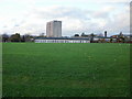
St Julians Junior School playing fields
Looking across the playing fields from the end of Flint Close. http://www.geograph.org.uk/photo/1557700
The top part of a wing of St Julians Junior School is visible, and behind the school is Greenwood http://www.geograph.org.uk/photo/1557224 multi-storey flats.
Image: © Jaggery
Taken: 1 Nov 2009
0.12 miles
10
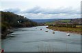
Afon Wysg (River Usk) northeast of Newport
A stretch of the Afon Wysg (River Usk) to the northeast of the city of Newport (Gwent, formerly Monmouthshire). The Usk has a particularly serpentine course at this point, meandering in wide arcs as it flows towards the sea.
The photo was taken from a covered decked area adjoining the St Julian Inn http://www.stjulian.co.uk (which serves very reasonably priced food) to the south of the historic town of Caerleon.
Image: © Rob Farrow
Taken: 1 Apr 2016
0.13 miles