IMAGES TAKEN NEAR TO
Church Court, NEWPORT, NP19 7NJ
Introduction
This page details the photographs taken nearby to Church Court, NP19 7NJ by members of the Geograph project.
The Geograph project started in 2005 with the aim of publishing, organising and preserving representative images for every square kilometre of Great Britain, Ireland and the Isle of Man.

There are currently over 7.5m images from over14,400 individuals and you can help contribute to the project by visiting https://www.geograph.org.uk
Image Map
Images are licensed for reuse under creativecommons.org/licenses/by-sa/2.0
Notes
- Clicking on the map will re-center to the selected point.
- The higher the marker number, the further away the image location is from the centre of the postcode.
Image Listing (64 Images Found)
Images are licensed for reuse under creativecommons.org/licenses/by-sa/2.0
Image
Details
Distance

2
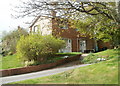
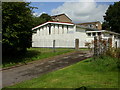
The Manse, Beaufort Road, Newport
House on the west side of St Julians Baptist Church. http://www.geograph.org.uk/photo/1457279 It was until recently the residence of the church pastor.
Image: © Jaggery
Taken: 14 Apr 2011
0.05 miles
3
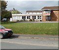
St Julians Baptist Church hall
The hall is located on the west side of the church http://www.geograph.org.uk/photo/1457279 on Beaufort Road.
Image: © Jaggery
Taken: 14 Apr 2011
0.05 miles
4
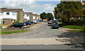
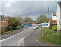
Monmouth Drive,Newport
Looking north from Beaufort Road. Just out of view beyond the right edge of the photo is the Greenwood multi-storey flats building. http://www.geograph.org.uk/photo/1557224
Image: © Jaggery
Taken: 20 Aug 2009
0.06 miles
5
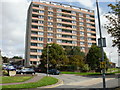
Greenwood Flats, St Julians, Newport
One of the few multi-storey flats in Newport, Greenwood is located on the north side of Beaufort Road, on the corner of Monmouth Drive.
Image: © Jaggery
Taken: 20 Aug 2009
0.06 miles
6
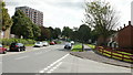
Beaufort Road, Newport
Looking east along Beaufort Road from the junction with Constable Drive. In the distance, on the left is the top of the Greenwood flats multi-storey building, which is located opposite St Julians Junior and Infants School.
Image: © Jaggery
Taken: 20 Aug 2009
0.06 miles
7
St Julius the Martyr, Newport
Roman Catholic church situated on Beaufort Road, a little east of St Julians Baptist.http://www.geograph.org.uk/photo/1457279
Set well back from the road, the church is hidden by trees from the view of those approaching from the west. It is named after the martyr Saint Julius of Caerleon.
Image: © Jaggery
Taken: 20 Aug 2009
0.06 miles
8
Unnamed connecting road from Constable Drive to Beaufort Road, Newport
This 60-metre long road gives the western side of Constable Drive a short cut to Beaufort Road, and thence to Caerleon Road and the M4 motorway.
Image: © Jaggery
Taken: 14 Apr 2011
0.07 miles
9
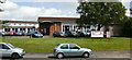
St Julians Baptist,Newport
St Julians Baptist Church Centre, 33 Beaufort Road, Newport. Set back from the road with onsite parking. Built in 1958, largely from the proceeds of the sale of Commercial Street Baptist Church. The building was designed as a place of light and rich colours to emphasise that it is a community centre as well as a church. It was built on a greenfield site in an area where the new St Julians estate was about to be built.
Image: © Jaggery
Taken: 20 Aug 2009
0.07 miles
