IMAGES TAKEN NEAR TO
Caerleon Road, NEWPORT, NP19 7LT
Introduction
This page details the photographs taken nearby to Caerleon Road, NP19 7LT by members of the Geograph project.
The Geograph project started in 2005 with the aim of publishing, organising and preserving representative images for every square kilometre of Great Britain, Ireland and the Isle of Man.

There are currently over 7.5m images from over14,400 individuals and you can help contribute to the project by visiting https://www.geograph.org.uk
Image Map
Images are licensed for reuse under creativecommons.org/licenses/by-sa/2.0
Notes
- Clicking on the map will re-center to the selected point.
- The higher the marker number, the further away the image location is from the centre of the postcode.
Image Listing (106 Images Found)
Images are licensed for reuse under creativecommons.org/licenses/by-sa/2.0
Image
Details
Distance
1
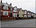
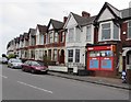
Row of houses, Caerleon Road, Newport
On the south side of the B4596 Caerleon Road, opposite semi-detached houses on the north side.
The CAERLEON ROAD name sign is on the wall on the left, at first floor level.
Image: © Jaggery
Taken: 22 Mar 2016
0.00 miles
2
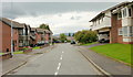
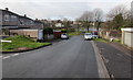
The Moorings, Newport
Looking east from near the Haisbro Avenue junction.
Image: © Jaggery
Taken: 23 Aug 2009
0.01 miles
3
Warning sign - traffic lights 100 yards ahead, Caerleon Road, Newport
On the approach to a pelican crossing. http://www.geograph.org.uk/photo/4876154
Image: © Jaggery
Taken: 22 Mar 2016
0.02 miles
4
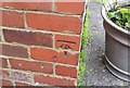
Ordnance Survey Cut Mark
This OS cut mark can be found on No449 Caerleon Road. It marks a point 24.997m above mean sea level.
Image: © Adrian Dust
Taken: 17 Jun 2018
0.02 miles
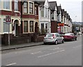
5
Ideal Stores, Caerleon Road, Newport
General stores and newsagent at 392 Caerleon Road.
Image: © Jaggery
Taken: 22 Mar 2016
0.03 miles
6
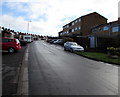
Down Ennerdale Court, Old Barn Estate, Newport
Ennerdale Court descends past the Buttermere Way junction towards the Coniston Close junction.
Image: © Jaggery
Taken: 30 Mar 2016
0.03 miles
7
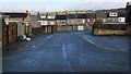
Coniston Close, Old Barn Estate, Newport
Looking towards the backs of Caerleon Road houses.
Image: © Jaggery
Taken: 30 Mar 2016
0.04 miles
8
Ennerdale Court, Old Barn Estate, Newport
The streets in Old Barn Estate were named using an English Lake District theme.
Other examples are Coniston Close and Buttermere Way.
Image: © Jaggery
Taken: 30 Mar 2016
0.05 miles
9
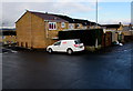
MII Engineering van in Coniston Close, Old Barn Estate, Newport
Based in Pant Glas Industrial Estate, Bedwas, MII's business is engineering installation, erection,
maintenance & repair of machinery, plant, steelwork and associated services.
Image: © Jaggery
Taken: 30 Mar 2016
0.06 miles
10
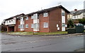
Riverview, The Moorings, Newport
A building of 8 flats at the west end of The Moorings, viewed from the corner of Haisbro Avenue and Cumberland Road.
Image: © Jaggery
Taken: 2 Dec 2010
0.06 miles