IMAGES TAKEN NEAR TO
Tudor Road, NEWPORT, NP19 7JY
Introduction
This page details the photographs taken nearby to Tudor Road, NP19 7JY by members of the Geograph project.
The Geograph project started in 2005 with the aim of publishing, organising and preserving representative images for every square kilometre of Great Britain, Ireland and the Isle of Man.

There are currently over 7.5m images from over14,400 individuals and you can help contribute to the project by visiting https://www.geograph.org.uk
Image Map
Images are licensed for reuse under creativecommons.org/licenses/by-sa/2.0
Notes
- Clicking on the map will re-center to the selected point.
- The higher the marker number, the further away the image location is from the centre of the postcode.
Image Listing (173 Images Found)
Images are licensed for reuse under creativecommons.org/licenses/by-sa/2.0
Image
Details
Distance
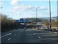
1
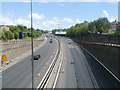
Newport : M4 motorway climbs away from junction 25
The view ESE from the Caerleon Road bridge, past the slip roads on either side of the motorway.
Image: © Jaggery
Taken: 8 May 2011
0.03 miles
2
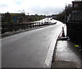
Exit slip road from the M4 motorway westbound at junction 25, Newport
The B4596 Caerleon Road is behind the camera.
Image: © Jaggery
Taken: 30 Mar 2016
0.06 miles
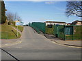
4
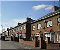
Tudor Road, St Julians, Newport
Houses on the west side of Tudor Road, viewed from near the M4 motorway end of the street, looking in the direction of Heather Road.
Image: © Jaggery
Taken: 4 Mar 2010
0.07 miles
5
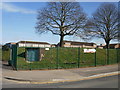
Western entrance to St Julians School, Newport
Viewed from Heather Road.
Image: © Jaggery
Taken: 4 Mar 2010
0.07 miles
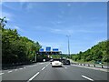
6
M4 junction 25
Twmbarlwm Hill Fort on the skyline above the Cardiff sign. [Looking NW]
Image: © John Thorn
Taken: 21 Jan 2006
0.07 miles
7
The far end of Denbigh Road, St Julians, Newport
The entrance to Denbigh Road is from Heather Road. The far end of the street is at the M4 motorway wall. Beyond the motorway is Old Barn housing estate.
Image: © Jaggery
Taken: 4 Mar 2010
0.07 miles
8
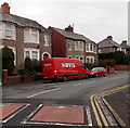
Red Hovis van in Heather Road, Newport
The name D.Gibbon & Sons is on the van parked near the junction of Tudor Road (ahead).
Image: © Jaggery
Taken: 27 Nov 2014
0.07 miles
9
St Julians School, Newport
The school is set back nearly 100 metres from Heather Road.
It opened in 1941 as a secondary school. Following the introduction of the 11-plus examination by the 1944 Education Act, the school became St Julians High School, a Grammar School. It became a comprehensive school in the mid 1960s.
Image: © Jaggery
Taken: 4 Mar 2010
0.07 miles
10
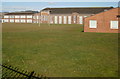
St Julians School, Newport, viewed from the east
Viewed from the railings near the school's eastern entrance on Heather Road.
The main buildings are set back about 100 metres from the road, on the far side of
a rugby pitch.
St Julians opened in 1941 as a secondary school. Following the introduction of the 11-plus examination by the 1944 Education Act, the school became St Julians High School, a Grammar School. It became a comprehensive school in the mid 1960s.
Image: © Jaggery
Taken: 4 Mar 2010
0.07 miles