IMAGES TAKEN NEAR TO
Sutton Road, NEWPORT, NP19 7JF
Introduction
This page details the photographs taken nearby to Sutton Road, NP19 7JF by members of the Geograph project.
The Geograph project started in 2005 with the aim of publishing, organising and preserving representative images for every square kilometre of Great Britain, Ireland and the Isle of Man.

There are currently over 7.5m images from over14,400 individuals and you can help contribute to the project by visiting https://www.geograph.org.uk
Image Map
Images are licensed for reuse under creativecommons.org/licenses/by-sa/2.0
Notes
- Clicking on the map will re-center to the selected point.
- The higher the marker number, the further away the image location is from the centre of the postcode.
Image Listing (195 Images Found)
Images are licensed for reuse under creativecommons.org/licenses/by-sa/2.0
Image
Details
Distance
1
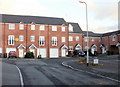
Orchard Gardens, Newport
Modern housing, built c2005, located in a cul-de-sac set back from the east side of Durham Road, between Stafford Road and Oak Street.
Image: © Jaggery
Taken: 24 Jan 2010
0.01 miles
2
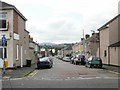
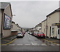
Oak Street, Newport
Oak Street heads away from Caerleon Road towards Durham Road. The far end of Oak Street is at the edge of the Newport to Cwmbran and The North railway line.
Image: © Jaggery
Taken: 6 Sep 2009
0.01 miles
3
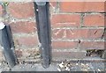
Ordnance Survey Cut Mark
This OS cut mark can be found on the wall of No14 Sutton Road. It marks a point 11.415m above mean sea level.
Image: © Adrian Dust
Taken: 9 Jun 2018
0.03 miles
4
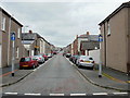
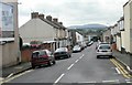
Oak Street, Newport
Looking along Oak Street from Stockton Road. Oak Street crosses Sutton Road and Durham Road before joining Caerleon Road.
Image: © Jaggery
Taken: 16 Aug 2009
0.05 miles
5
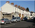
Stafford Road, Newport
Houses on the north side of Stafford Road, viewed from the corner of Durham Road.
Image: © Jaggery
Taken: 7 Mar 2010
0.06 miles
6
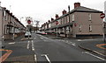
Stafford Road, Newport
Stafford Road heads away from Caerleon Road towards Durham Road. The far end of Stafford Road is at the corner of Stockton Road, on the edge of the Newport to Cwmbran and The North railway line.
Image: © Jaggery
Taken: 6 Sep 2009
0.06 miles
7
Six No Entry signs in Newport
At the crossroads of Durham Road and Oak Street. No entry to Oak Street (left or right) or Durham Road ahead. The scene is not as nightmarish as it appears. No Entry signs at the Stafford Road junction 150 metres behind the camera should have prevented vehicles reaching this location in this direction.
Image: © Jaggery
Taken: 27 Nov 2014
0.06 miles
8
West along Stafford Road, Newport
Car-lined Stafford Road viewed across Caerleon Road.
Image: © Jaggery
Taken: 9 Nov 2019
0.06 miles
9
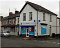
Mayberry Pharmacy, Newport
On the corner of Durham Road and Stafford Road, formerly occupied by Inspirations. http://www.geograph.org.uk/photo/1977121
Mayberry Pharmacy, formerly in Caerleon Road, is now opposite St Julians Medical Centre. http://www.geograph.org.uk/photo/1427893 Inspirations is now (November 2014) located in a Caerleon Road shop. http://www.geograph.org.uk/photo/4260964
Image: © Jaggery
Taken: 27 Nov 2014
0.07 miles
10
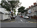
Durham Road , Newport
Looking south along Durham Road from its junction with Bank Street
Image: © Jaggery
Taken: 2 Aug 2009
0.07 miles