IMAGES TAKEN NEAR TO
Haisbro Avenue, NEWPORT, NP19 7HY
Introduction
This page details the photographs taken nearby to Haisbro Avenue, NP19 7HY by members of the Geograph project.
The Geograph project started in 2005 with the aim of publishing, organising and preserving representative images for every square kilometre of Great Britain, Ireland and the Isle of Man.

There are currently over 7.5m images from over14,400 individuals and you can help contribute to the project by visiting https://www.geograph.org.uk
Image Map
Images are licensed for reuse under creativecommons.org/licenses/by-sa/2.0
Notes
- Clicking on the map will re-center to the selected point.
- The higher the marker number, the further away the image location is from the centre of the postcode.
Image Listing (110 Images Found)
Images are licensed for reuse under creativecommons.org/licenses/by-sa/2.0
Image
Details
Distance
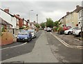
1
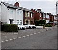
White house and white cars, Haisbro Avenue, Newport
Haisbro Avenue is a cul-de-sac between Caerleon Road and the south bank of the River Usk.
Image: © Jaggery
Taken: 22 Mar 2016
0.01 miles
2
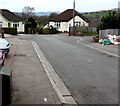
Haisbro Avenue turning circle, Newport
At the western end of Haisbro Avenue, 160 metres from the Caerleon Road junction.
Image: © Jaggery
Taken: 22 Mar 2016
0.03 miles
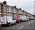
3
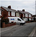
Thrifty van, Haisbro Avenue, Newport
In March 2016, the Thrifty Car & Van Rental website states that Thrifty currently operates in 95 locations in the UK. The head office is in Exeter where the accounts, human resources, insurance, fleet and car sales departments are based. The business also has a central office in High Wycombe where the sales, call centre and customer service departments are located.
Image: © Jaggery
Taken: 22 Mar 2016
0.03 miles

5
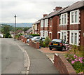
Haisbro Avenue, Newport
Houses on the north side of Haisbro Avenue.
Image: © Jaggery
Taken: 16 Aug 2009
0.05 miles
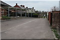
6
Haisbro Avenue, Newport
The view from the far end of Haisbro Avenue, looking in the direction of Caerleon Road and the turnings for The Moorings and Cumberland Road.
Image: © Jaggery
Taken: 18 Jul 2010
0.05 miles
7
Telecoms cabinets on a Newport corner
On the corner of Haisbro Avenue and The Moorings.
Image: © Jaggery
Taken: 22 Mar 2016
0.06 miles
8
Colas Rail van, Cumberland Road, Newport
The Colas Group website states that its railway division is one of the world's leading providers of railway infrastructure services. In the UK Colas Rail combines the engineering skills of all their specialist businesses to provide total solutions in all aspects of railway infrastructure, from high speed rail systems to light and urban railways.
Image: © Jaggery
Taken: 22 Mar 2016
0.06 miles
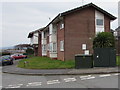
9
Access road to St Julians Lodge, Newport
On the west side of Haisbro Avenue. The parking area on the left is for residents and their visitors only.
Image: © Jaggery
Taken: 22 Mar 2016
0.07 miles
10
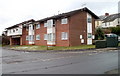
Riverview, The Moorings, Newport
A building of 8 flats at the west end of The Moorings, viewed from the corner of Haisbro Avenue and Cumberland Road.
Image: © Jaggery
Taken: 2 Dec 2010
0.07 miles