IMAGES TAKEN NEAR TO
Richmond Road, NEWPORT, NP19 7GH
Introduction
This page details the photographs taken nearby to Richmond Road, NP19 7GH by members of the Geograph project.
The Geograph project started in 2005 with the aim of publishing, organising and preserving representative images for every square kilometre of Great Britain, Ireland and the Isle of Man.

There are currently over 7.5m images from over14,400 individuals and you can help contribute to the project by visiting https://www.geograph.org.uk
Image Map (Loading...)


Getting Data...Please wait
Leaflet Map data © OpenStreetMap
Images are licensed for reuse under creativecommons.org/licenses/by-sa/2.0
Notes
- Clicking on the map will re-center to the selected point.
- The higher the marker number, the further away the image location is from the centre of the postcode.
Image Listing (270 Images Found)
Images are licensed for reuse under creativecommons.org/licenses/by-sa/2.0
Image
Details
Distance
1
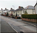
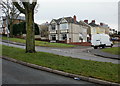
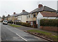
Surrey Place, St Julians, Newport
Houses on the east side of Surrey Place, viewed from the St Julians Road end.
Image: © Jaggery
Taken: 25 Feb 2010
0.02 miles
2
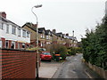
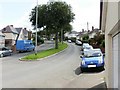
Ronald Road, St Julians, Newport
Houses on the west side of Ronald Road, viewed from the St Julians Road end.
Image: © Jaggery
Taken: 25 Feb 2010
0.02 miles
3
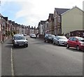
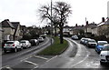
Up Somerset Road, Newport
Somerset Road ascends from Caerleon Road towards Christchurch Road.
This is a one-way road, direction downhill.
Image: © Jaggery
Taken: 6 Oct 2017
0.05 miles
4
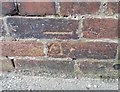
Ordnance Survey Cut Mark
This OS cut mark can be found on No63 Somerset Road. It marks a point 33.543m above mean sea level.
Image: © Adrian Dust
Taken: 9 Jun 2018
0.07 miles
5
Corner of Ronald Road, St Julians, Newport
Looking across the grassed central reservation of St Julians Road towards houses on the corner of Ronald Road.
Image: © Jaggery
Taken: 25 Feb 2010
0.08 miles
6
St Julians Road, Newport
Looking east along St Julians Road from the junction with St Julians Avenue.
Image: © Jaggery
Taken: 13 Aug 2009
0.08 miles
7
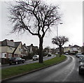
Trees on a grass strip, St Julians Road, Newport
Viewed on March 30th 2016. It will be several weeks before these trees are in leaf.
Image: © Jaggery
Taken: 30 Mar 2016
0.09 miles
8
Bend in St Julians Road, Newport
Viewed from the grass strip in the middle of the dual carriageway part of St Julians Road.
Image: © Jaggery
Taken: 30 Mar 2016
0.09 miles
9
Cornwall Road, St Julians, Newport
Houses on the west side of Cornwall Road, viewed from the St Julians Road end.
Image: © Jaggery
Taken: 25 Feb 2010
0.10 miles
10
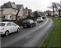
Dual carriageway part of St Julians Road, Newport
Trees and a grassy strip separate the two carriageways.
Image: © Jaggery
Taken: 30 Mar 2016
0.10 miles