IMAGES TAKEN NEAR TO
Church Road, NEWPORT, NP19 7EJ
Introduction
This page details the photographs taken nearby to Church Road, NP19 7EJ by members of the Geograph project.
The Geograph project started in 2005 with the aim of publishing, organising and preserving representative images for every square kilometre of Great Britain, Ireland and the Isle of Man.

There are currently over 7.5m images from over14,400 individuals and you can help contribute to the project by visiting https://www.geograph.org.uk
Image Map
Images are licensed for reuse under creativecommons.org/licenses/by-sa/2.0
Notes
- Clicking on the map will re-center to the selected point.
- The higher the marker number, the further away the image location is from the centre of the postcode.
Image Listing (746 Images Found)
Images are licensed for reuse under creativecommons.org/licenses/by-sa/2.0
Image
Details
Distance
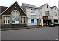
1
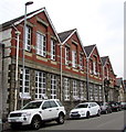
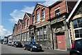
Former school building, Church Road, Newport
In June 2016 the building is the head office of GAVO (Gwent Association of Voluntary Organisations).
Image: © Jaggery
Taken: 10 Jun 2016
0.01 miles
2
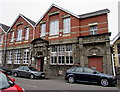
GAVO Head Office, Church Road, Newport
The head office of GAVO (Gwent Association of Voluntary Organisations) is in a former school building.
The stone inscription INFANTS is over the doorway above the open door.
Image: © Jaggery
Taken: 10 Jun 2016
0.01 miles
4
R J Phillips Interiors, Newport
Makers & sellers of bespoke curtains, blinds and accessories at 59 Church Road, on the corner of Hereford Street.
Image: © Jaggery
Taken: 6 Apr 2018
0.01 miles
5
Fairoak Nursery School, Newport
Located in Church Road, opposite Hereford Street. Notices in the window on the left show Fairoak Nursery School. Also in view are a Welsh Conservatives office and King Kebab.
Image: © Jaggery
Taken: 10 Jun 2016
0.02 miles
6
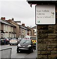
Ysgol Feithrin Fairoak/Fairoak Nursery School name sign, Church Road, Newport
The Welsh/English sign is at the entrance here. https://www.geograph.org.uk/photo/2803187
Image: © Jaggery
Taken: 9 Mar 2019
0.02 miles
7
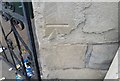
Ordnance Survey Cut Mark
This OS cut mark can be found on Fairoak School. It marks a point 8.098m above mean sea level.
Image: © Adrian Dust
Taken: 9 Jun 2018
0.02 miles
8
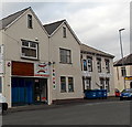
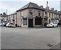
Paprika Indian takeaway, Newport
The takeaway is at 16 Church Road, viewed from the corner of Hereford Street.
Image: © Jaggery
Taken: 1 Mar 2013
0.02 miles
9
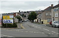
Junction Road, Barnardtown
Looking along Junction Road, Barnardtown, Newport from Caerleon Road towards Duckpool Road
Image: © Jaggery
Taken: 16 Aug 2009
0.03 miles
10
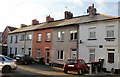
Lord Street, Barnardtown, Newport
Houses on the west side of a short cul-de-sac, viewed from Junction Road.
Image: © Jaggery
Taken: 3 Dec 2009
0.03 miles