IMAGES TAKEN NEAR TO
Riverbank Avenue, NEWPORT, NP19 7EF
Introduction
This page details the photographs taken nearby to Riverbank Avenue, NP19 7EF by members of the Geograph project.
The Geograph project started in 2005 with the aim of publishing, organising and preserving representative images for every square kilometre of Great Britain, Ireland and the Isle of Man.

There are currently over 7.5m images from over14,400 individuals and you can help contribute to the project by visiting https://www.geograph.org.uk
Image Map
Images are licensed for reuse under creativecommons.org/licenses/by-sa/2.0
Notes
- Clicking on the map will re-center to the selected point.
- The higher the marker number, the further away the image location is from the centre of the postcode.
Image Listing (145 Images Found)
Images are licensed for reuse under creativecommons.org/licenses/by-sa/2.0
Image
Details
Distance
1
J.S.Payne, Herbert Road, Newport
This is Enterprise House, the Herbert Road premises of J.S.Payne Limited, Engineering and Fabrication. They specialise in structural steelwork, and architectural steelwork including staircases, balustrading and handrailing.
Image: © Jaggery
Taken: 30 Aug 2009
0.02 miles
2
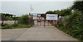
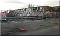
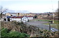
Construction site at the far end of Herbert Road, Newport
Herbert Road ends at the edge of a Norwest Holst construction site. Work was ongoing here on the construction of the new Glan Usk school, which opened in January 2010, a few months after this photo was taken.
Image: © Jaggery
Taken: 30 Aug 2009
0.02 miles
3
Locked door on landing stage, River Usk, Newport
The door is an imaginative way to prevent would-be intruders using the landing stage on the east bank of the River Usk.
Image: © Jaggery
Taken: 4 Apr 2010
0.04 miles
4
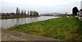
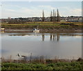
Upstream along the River Usk, Newport
Viewed over the Riverside flood defence wall.
Image: © Jaggery
Taken: 19 Jan 2017
0.05 miles
5
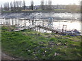
Landing stage, River Usk, Newport
Looking across the River Usk from Shaftesbury Park towards a boat and landing stage on the east bank of the river.
Image: © Jaggery
Taken: 28 Dec 2009
0.07 miles
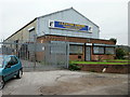
6
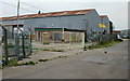
Skate Extreme, Newport
At first glance, seemingly derelict premises, this is in fact the home of Skate Extreme, a skate park. Features include half pipes, quarter pipes, a foam box, and a range of ramps. Used by skating enthusiasts and bikers.
Update : The skate park was destroyed by fire in March 2010. http://www.geograph.org.uk/photo/1800593
Image: © Jaggery
Taken: 30 Aug 2009
0.07 miles
7
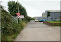
Don't kill the workforce, Herbert Road, Newport
The sign urges you to kill your speed, not the workforce. To reinforce the big 15 sign, behind it another sign spells out MAX SPEED LIMIT 15 MPH, and also reminds you of where you are. On the right is Skate Extreme. http://www.geograph.org.uk/photo/1712843
Image: © Jaggery
Taken: 30 Aug 2009
0.07 miles
8
Skate park destroyed by fire, Herbert Road, Newport
In March 2010, fire destroyed CJ's Skatepark (formerly known as Skate Extreme).
The owner of the family-run business estimated the damage at up to £2 million.
The cause of the fire has not yet been reported.
Skate Extreme was opened in 1996 at the former Jewson's builders' yard, with the aim of attracting skateboarders, rollerbladers, BMXs and micro-scooters.
http://www.geograph.org.uk/photo/1712843 to the premises in August 2009.
Image: © Jaggery
Taken: 11 Apr 2010
0.07 miles
9
TS Resolute, Newport
Newport Sea Cadets premises adjacent to the east bank of the river Usk.
'TS' stands for Training Ship, the name used for any Sea Cadets' unit.
The Sea Cadet Corps is a nationwide voluntary uniformed youth organisation, open to all young people aged 12 to 18. The remit of the Sea Cadets is to provide fun, friendship, adventure while learning new skills based on waterborne and land-based activities.
In the middle background, behind TS Resolute, are the mangled remains of the former skateparkhttp://www.geograph.org.uk/photo/1800593 recently destroyed by fire.
Image: © Jaggery
Taken: 4 Apr 2010
0.08 miles
10
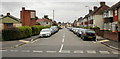
Margaret Avenue, Newport
From the junction with Orchard Street.
Image: © Jaggery
Taken: 16 Aug 2009
0.08 miles