IMAGES TAKEN NEAR TO
York Road, NEWPORT, NP19 7DT
Introduction
This page details the photographs taken nearby to York Road, NP19 7DT by members of the Geograph project.
The Geograph project started in 2005 with the aim of publishing, organising and preserving representative images for every square kilometre of Great Britain, Ireland and the Isle of Man.

There are currently over 7.5m images from over14,400 individuals and you can help contribute to the project by visiting https://www.geograph.org.uk
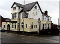
Image Map
Images are licensed for reuse under creativecommons.org/licenses/by-sa/2.0
Notes
- Clicking on the map will re-center to the selected point.
- The higher the marker number, the further away the image location is from the centre of the postcode.
Image Listing (283 Images Found)
Images are licensed for reuse under creativecommons.org/licenses/by-sa/2.0
Image
Details
Distance
1
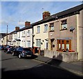
York Road houses, Newport
On the north side of York Road between Caerleon Road and Durham Road.
Image: © Jaggery
Taken: 6 Oct 2017
0.01 miles
2
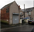
York Road premises of E.J. Herbert & Son Memorials, Newport
On the corner of York Road and Morden Lane. The name sign on the wall states
that the business's office and showroom is at 123 Corporation Road, Newport.
Image: © Jaggery
Taken: 30 Mar 2016
0.02 miles
3
York Road, Newport
Looking east from Durham Road along York Road towards Caerleon Road.
Fortune House http://www.geograph.org.uk/photo/4260548 is on the left.
Image: © Jaggery
Taken: 27 Nov 2014
0.02 miles
4

Fortune House, Newport
Durham Road Chinese takeaway on the corner of York Road.
Image: © Jaggery
Taken: 27 Nov 2014
0.02 miles
5
Caerleon Road Betfred, Newport
Betting shop on the corner of Caerleon Road and York Road, next door
to a Monmouthshire Building Society branch near two BT phoneboxes.
Image: © Jaggery
Taken: 6 Oct 2017
0.03 miles
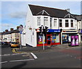
6
The Victoria, Caerleon Road, Newport
Recently refurbished pub on the corner of Caerleon Road and York Road, viewed in late March 2016.
Here's http://www.geograph.org.uk/photo/1463084 how it looked in August 2009.
http://www.geograph.org.uk/photo/4886361 to a closer view of the Penny Black name sign.
Image: © Jaggery
Taken: 30 Mar 2016
0.03 miles
7
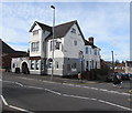
The Victoria, Caerleon Road, Newport
Pub on the corner of York Road, viewed in October 2017. http://www.geograph.org.uk/photo/5561047 to the pub name sign.
http://www.geograph.org.uk/photo/1463084 to an August 2009 view of the pub.
Image: © Jaggery
Taken: 6 Oct 2017
0.03 miles
8

York Road side of the Victoria pub, Newport
The north side of the Caerleon Road pub. http://www.geograph.org.uk/photo/5561035
Image: © Jaggery
Taken: 6 Oct 2017
0.03 miles
9
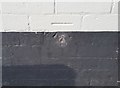
Ordnance Survey Cut Mark
This OS cut mark can be found on the Victoria PH. It marks a point 12.708m above mean sea level.
Image: © Adrian Dust
Taken: 9 Jun 2018
0.03 miles
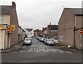
10
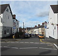
Junction of Caerleon Road and York Road, Newport
The 30mph speed limit on Caerleon Road drops to 20mph along one-way York Road.
The Victoria pub http://www.geograph.org.uk/photo/5561035 is on the left.
Image: © Jaggery
Taken: 6 Oct 2017
0.03 miles