IMAGES TAKEN NEAR TO
Durham Road, NEWPORT, NP19 7DP
Introduction
This page details the photographs taken nearby to Durham Road, NP19 7DP by members of the Geograph project.
The Geograph project started in 2005 with the aim of publishing, organising and preserving representative images for every square kilometre of Great Britain, Ireland and the Isle of Man.

There are currently over 7.5m images from over14,400 individuals and you can help contribute to the project by visiting https://www.geograph.org.uk
Image Map
Images are licensed for reuse under creativecommons.org/licenses/by-sa/2.0
Notes
- Clicking on the map will re-center to the selected point.
- The higher the marker number, the further away the image location is from the centre of the postcode.
Image Listing (254 Images Found)
Images are licensed for reuse under creativecommons.org/licenses/by-sa/2.0
Image
Details
Distance
1
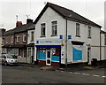
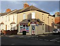
Mayberry Pharmacy, Newport
On the corner of Durham Road and Stafford Road, formerly occupied by Inspirations. http://www.geograph.org.uk/photo/1977121
Mayberry Pharmacy, formerly in Caerleon Road, is now opposite St Julians Medical Centre. http://www.geograph.org.uk/photo/1427893 Inspirations is now (November 2014) located in a Caerleon Road shop. http://www.geograph.org.uk/photo/4260964
Image: © Jaggery
Taken: 27 Nov 2014
0.02 miles
2
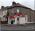
R M & B Convenience Store, Newport
The several instances of The Sun are more conspicuous than the name
of the business on the corner of Durham Road and Orchard Street.
Image: © Jaggery
Taken: 27 Nov 2014
0.02 miles
3
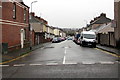
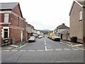
West along Orchard Street, Newport
From Caerleon Road along Orchard Street towards Durham Road.
The 30mph speed limit drops to 20mph on the approach to Glan Usk Primary School.
Image: © Jaggery
Taken: 9 Nov 2019
0.02 miles
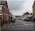
4
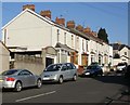
Stafford Road, Newport
Houses on the north side of Stafford Road, viewed from the corner of Durham Road.
Image: © Jaggery
Taken: 7 Mar 2010
0.02 miles
5
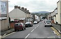
Stafford Road, Newport
Stafford Road heads away from Caerleon Road towards Durham Road. The far end of Stafford Road is at the corner of Stockton Road, on the edge of the Newport to Cwmbran and The North railway line.
Image: © Jaggery
Taken: 6 Sep 2009
0.02 miles
6
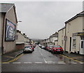
West along Stafford Road, Newport
Car-lined Stafford Road viewed across Caerleon Road.
Image: © Jaggery
Taken: 9 Nov 2019
0.02 miles
7
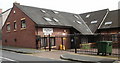
St Julians Medical Centre, Newport
On Stafford Road at its junction with Durham Road.
Image: © Jaggery
Taken: 2 Aug 2009
0.03 miles
8
Orchard Street, Newport
The 30mph speed limit on Caerleon Road drops to 20mph along Orchard Street on the approach to a school.
Image: © Jaggery
Taken: 30 Mar 2016
0.03 miles
9
Orchard Street, Newport
Orchard Street heads away from Caerleon Road, towards Durham Road. The far end of Orchard Street is adjacent to Margaret Avenue, and the Newport to Cwmbran and The North railway line. http://www.geograph.org.uk/photo/2089389
Image: © Jaggery
Taken: 6 Sep 2009
0.04 miles
10
Goddard Stores, Newport
Shop on the corner of Durham Road and Orchard Street. General stores, newsagent and off-licence.
Image: © Jaggery
Taken: 31 Jan 2010
0.04 miles