IMAGES TAKEN NEAR TO
Orchard Street, NEWPORT, NP19 7DN
Introduction
This page details the photographs taken nearby to Orchard Street, NP19 7DN by members of the Geograph project.
The Geograph project started in 2005 with the aim of publishing, organising and preserving representative images for every square kilometre of Great Britain, Ireland and the Isle of Man.

There are currently over 7.5m images from over14,400 individuals and you can help contribute to the project by visiting https://www.geograph.org.uk
Image Map
Images are licensed for reuse under creativecommons.org/licenses/by-sa/2.0
Notes
- Clicking on the map will re-center to the selected point.
- The higher the marker number, the further away the image location is from the centre of the postcode.
Image Listing (255 Images Found)
Images are licensed for reuse under creativecommons.org/licenses/by-sa/2.0
Image
Details
Distance
1
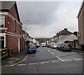
Orchard Street, Newport
The 30mph speed limit on Caerleon Road drops to 20mph along Orchard Street on the approach to a school.
Image: © Jaggery
Taken: 30 Mar 2016
0.02 miles
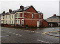
2
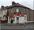
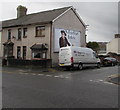
R M & B Convenience Store, Newport
The several instances of The Sun are more conspicuous than the name
of the business on the corner of Durham Road and Orchard Street.
Image: © Jaggery
Taken: 27 Nov 2014
0.03 miles
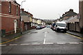
3
West along Stafford Road, Newport
From Caerleon Road.
Image: © Jaggery
Taken: 30 Mar 2016
0.03 miles
4
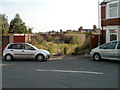
Waste ground, Hubert Road, Newport
Secured by a padlocked gate, the waste ground is located near the southern end of Hubert Road, opposite a 45-degree bend in the course of the road as it approaches St Julians Avenue.
Image: © Jaggery
Taken: 8 Aug 2010
0.03 miles
5
Junction of Caerleon Road and Orchard Street, Newport
Viewed across the B4596 Caerleon Road.
Image: © Jaggery
Taken: 9 Nov 2019
0.04 miles
6
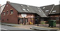
St Julians Medical Centre, Newport
On Stafford Road at its junction with Durham Road.
Image: © Jaggery
Taken: 2 Aug 2009
0.04 miles
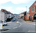
7
West along Orchard Street, Newport
From Caerleon Road along Orchard Street towards Durham Road.
The 30mph speed limit drops to 20mph on the approach to Glan Usk Primary School.
Image: © Jaggery
Taken: 9 Nov 2019
0.04 miles
8
Caerleon Road climbs toward M4 junction 25, Newport
Having followed a level course since its beginnings at Clarence Place, Caerleon Road (B4596) now climbs towards the roundabout above the M4 motorway at junction 25.
On the right is St Julians Methodist church. http://www.geograph.org.uk/photo/1426314
Image: © Jaggery
Taken: 25 Jul 2010
0.04 miles
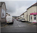
9
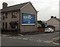
Halifax Bank advertising on a Caerleon Road corner wall, Newport
On the corner of Caerleon Road and Stafford Road.
Image: © Jaggery
Taken: 27 Nov 2014
0.04 miles
10
FW Express van, Stafford Road, Newport
Viewed across Caerleon Road. Text on the van includes UK / EU Freight.
Image: © Jaggery
Taken: 30 Mar 2016
0.04 miles