IMAGES TAKEN NEAR TO
Annealing Grove, NEWPORT, NP19 4UA
Introduction
This page details the photographs taken nearby to Annealing Grove, NP19 4UA by members of the Geograph project.
The Geograph project started in 2005 with the aim of publishing, organising and preserving representative images for every square kilometre of Great Britain, Ireland and the Isle of Man.

There are currently over 7.5m images from over14,400 individuals and you can help contribute to the project by visiting https://www.geograph.org.uk
Image Map
Images are licensed for reuse under creativecommons.org/licenses/by-sa/2.0
Notes
- Clicking on the map will re-center to the selected point.
- The higher the marker number, the further away the image location is from the centre of the postcode.
Image Listing (10 Images Found)
Images are licensed for reuse under creativecommons.org/licenses/by-sa/2.0
Image
Details
Distance
1
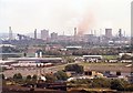
Llanwern Steel Works, Newport
As seen from Newport Transporter Bridge in 1996.
Much of these works was demolished in 2004 following the closure in 2001 of steel making on this site.
Image: © Robin Drayton
Taken: Unknown
0.11 miles
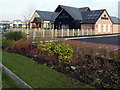
2
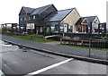
Llanwern Bull, Queen's Way, Newport
A Generous George pub & restaurant set back from the A4810 Queen's Way.
Image: © Jaggery
Taken: 27 Mar 2018
0.13 miles
3
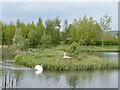
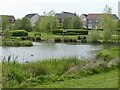
Swans, Western Park, Glan Llyn, Newport
A swan nesting on an island with an aggressive, protective mate.
Image: © Robin Drayton
Taken: 5 May 2022
0.13 miles
4
The Llanwern Bull, Queen's Way, Newport
A Generous George pub & restaurant set back from the A4810 Queen's Way.
Image: © Jaggery
Taken: 27 Mar 2018
0.13 miles
5
Rooftop solar panels on the Llanwern Bull, Newport
A Generous George pub & restaurant alongside the A4810 Queen's Way.
Image: © Jaggery
Taken: 27 Mar 2018
0.14 miles
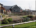
6
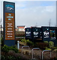
Information board outside the Llanwern Bull, Newport
The board is outside this https://www.geograph.org.uk/photo/5719322 Generous George pub & restaurant set back from the A4810 Queen's Way. In March 2018 the Llanwern Bull is open from 11am. Features include a pizza kitchen, handcrafted ales, kids' play space and cake & coffee.
Image: © Jaggery
Taken: 27 Mar 2018
0.14 miles
7
Western Park, Glan Llyn, Newport
For a plan of Glan Llyn see https://www.geograph.org.uk/photo/2794612 .
Image: © Robin Drayton
Taken: 5 May 2022
0.17 miles
8
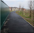
Path towards Bridling Crescent, Newport
From the north side of the A4810 Queen's Way.
Image: © Jaggery
Taken: 27 Mar 2018
0.18 miles
9
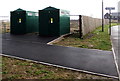
Queen's Way electricity substations, Newport
The Western Power Distribution electricity substations are alongside the A4810 Queen's Way on the SE side of the Glan Llyn housing development. The Generous George Llanwern Bull https://www.geograph.org.uk/photo/5719296 is in the background.
Image: © Jaggery
Taken: 27 Mar 2018
0.19 miles
10
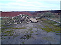
Industrial wasteland near Llanwern
Viewed through a fence on the north side of Queen's Way. http://www.geograph.org.uk/photo/2795844 This is a representative view of a derelict area roughly 2km west to east and 1km south to north that was formerly the western end of the massive Llanwern steelworks. This area has been derelict since closure in 2001. The land is now being redeveloped. http://www.geograph.org.uk/photo/2794519
Image: © Jaggery
Taken: 8 Feb 2012
0.20 miles