IMAGES TAKEN NEAR TO
Nash Road, NEWPORT, NP19 4TS
Introduction
This page details the photographs taken nearby to Nash Road, NP19 4TS by members of the Geograph project.
The Geograph project started in 2005 with the aim of publishing, organising and preserving representative images for every square kilometre of Great Britain, Ireland and the Isle of Man.

There are currently over 7.5m images from over14,400 individuals and you can help contribute to the project by visiting https://www.geograph.org.uk
Image Map
Images are licensed for reuse under creativecommons.org/licenses/by-sa/2.0
Notes
- Clicking on the map will re-center to the selected point.
- The higher the marker number, the further away the image location is from the centre of the postcode.
Image Listing (143 Images Found)
Images are licensed for reuse under creativecommons.org/licenses/by-sa/2.0
Image
Details
Distance
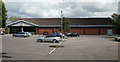
1
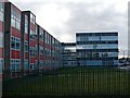
City of Newport Campus, Coleg Gwent
Commonly referred to as Nash College, it is part of the largest further education college in Wales.
Image: © Robin Drayton
Taken: 16 Feb 2010
0.03 miles
2
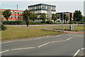
City of Newport Campus buildings
Located on the east side of Nash Road, this is one of five Coleg Gwent campuses.
Not to be confused with the recently-opened City Centre campus http://www.geograph.org.uk/photo/1886472 of the University of Wales, Newport.
Image: © Jaggery
Taken: 5 Aug 2011
0.05 miles
3
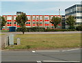
Red building, City of Newport campus
Viewed across Nash Road. The red (or perhaps orangy-red) building is at the northern edge of the site, one of five Coleg Gwent campuses.
Image: © Jaggery
Taken: 5 Aug 2011
0.05 miles
4
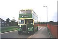
Bus for Pudsey
Newport Transport's old Leyland Titan at Nash Road terminus. It's running for the day to raise money for the BBC's annual Children in Need appeal.
Image: © David Roberts
Taken: Unknown
0.06 miles
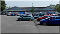
5
Aldi, Spytty Road, Newport
Aldi's Spytty Road store viewed from the far end of their spacious car park, accessed from Nash Road. http://www.geograph.org.uk/photo/2538817
Image: © Jaggery
Taken: 20 Aug 2009
0.06 miles
6
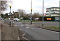
Zebra crossing on a hump, Nash Road, Newport
Part of traffic calming measures near Lliswerry High School.
Image: © Jaggery
Taken: 14 Jan 2019
0.08 miles
7
Alteration work in progress at Aldi Spytty Road, Newport
Viewed in early May 2014. The entrance on this side of the store is blocked off during alteration work. Shoppers are directed left to a temporary entrance. http://www.geograph.org.uk/photo/4008690
Image: © Jaggery
Taken: 5 May 2014
0.08 miles
8
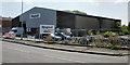
Magnet, Leeway Industrial Estate, Newport
Kitchen showroom premises situated close to the Spytty Road exit.
Image: © Jaggery
Taken: 20 Aug 2009
0.08 miles
9
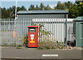
Postbox, Lee Way, Newport
The dozens of businesses on the Leeway Industrial Estate have their own postbox, for franked mail only, situated opposite Magnets premises near the Spytty Road junction.
Image: © Jaggery
Taken: 20 Aug 2009
0.08 miles
10
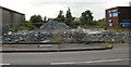
Neat piles of rubble, Leeway Industrial Estate, Newport
I don't know the use of the building, now rubble, formerly occupying this site next to Magnet http://www.geograph.org.uk/photo/1571167
Image: © Jaggery
Taken: 20 Aug 2009
0.08 miles