IMAGES TAKEN NEAR TO
Nash Road, NEWPORT, NP19 4RP
Introduction
This page details the photographs taken nearby to Nash Road, NP19 4RP by members of the Geograph project.
The Geograph project started in 2005 with the aim of publishing, organising and preserving representative images for every square kilometre of Great Britain, Ireland and the Isle of Man.

There are currently over 7.5m images from over14,400 individuals and you can help contribute to the project by visiting https://www.geograph.org.uk
Image Map
Images are licensed for reuse under creativecommons.org/licenses/by-sa/2.0
Notes
- Clicking on the map will re-center to the selected point.
- The higher the marker number, the further away the image location is from the centre of the postcode.
Image Listing (85 Images Found)
Images are licensed for reuse under creativecommons.org/licenses/by-sa/2.0
Image
Details
Distance
1
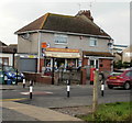
Nash Stores, Newport
83 Nash Road, close to the Traston Road junction.
Image: © Jaggery
Taken: 17 Dec 2009
0.03 miles
2
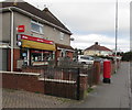
Queen Elizabeth II pillarbox outside Nash Stores, Nash Road, Newport
Viewed in January 2019. The appearance of Nash Stores has changed since this https://www.geograph.org.uk/photo/1623230 December 2009 photo.
Image: © Jaggery
Taken: 14 Jan 2019
0.05 miles
3
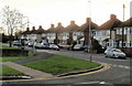
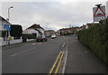
Nash Road, Newport
Houses on the west side of Nash Road, close to Lliswerry High School.
In the middle distance, above a chimney stack, is the top of a wind turbine on the south side of the Solutia site. http://www.geograph.org.uk/photo/1585741
Image: © Jaggery
Taken: 17 Dec 2009
0.06 miles
4
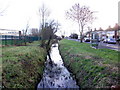
Reen, Nash Road, Newport
Looking south along a reen (drainage channel) between Lliswerry High School and Nash Road.
Image: © Jaggery
Taken: 17 Dec 2009
0.06 miles
5
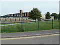
Lliswerry High School, Newport
The school is set back from the east side of Nash Road. The Coleg Gwent Nash campus is on the north side of the school, beyond the left edge of the view.
See http://www.geograph.org.uk/photo/1589246 for comments about the spellings Lliswerry and Liswerry.
Image: © Jaggery
Taken: 5 Aug 2011
0.07 miles
7
Northeast end of Traston Road, Newport
Viewed from the corner of Nash Road in January 2019.
Signs show Humps for 200 yards and ROAD CLOSED AHEAD.
Image: © Jaggery
Taken: 14 Jan 2019
0.07 miles
8
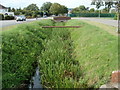
Nash Road reen, Newport
Lush early August vegetation covers much of the reen (drainage channel) on the east side of Nash Road, adjacent to Lliswerry High School. http://www.geograph.org.uk/photo/2538804
Image: © Jaggery
Taken: 5 Aug 2011
0.07 miles
9
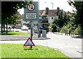
Inappropriate sign, Nash Road, Newport
Beneath a permanent 'give way' sign is a small, moveable 'flood' sign - on a dry and sunny day in August, and no recent heavy rain. Perhaps a water main had recently burst, but there was no evidence of that.
The turning on the left is an entry to Nash College, officially Coleg Gwent, City of Newport campus.
Image: © Jaggery
Taken: 20 Aug 2009
0.07 miles
10
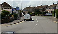
Traston Road, Newport
Traston Road viewed from Nash Road.
Image: © Jaggery
Taken: 20 Aug 2009
0.07 miles