IMAGES TAKEN NEAR TO
Hampshire Crescent, NEWPORT, NP19 4QN
Introduction
This page details the photographs taken nearby to Hampshire Crescent, NP19 4QN by members of the Geograph project.
The Geograph project started in 2005 with the aim of publishing, organising and preserving representative images for every square kilometre of Great Britain, Ireland and the Isle of Man.

There are currently over 7.5m images from over14,400 individuals and you can help contribute to the project by visiting https://www.geograph.org.uk
Image Map
Images are licensed for reuse under creativecommons.org/licenses/by-sa/2.0
Notes
- Clicking on the map will re-center to the selected point.
- The higher the marker number, the further away the image location is from the centre of the postcode.
Image Listing (156 Images Found)
Images are licensed for reuse under creativecommons.org/licenses/by-sa/2.0
Image
Details
Distance
1
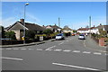
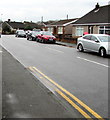
Hampshire Crescent, Newport
Viewed across Hampshire Avenue looking along Hampshire Crescent towards Derby Grove.
Image: © Jaggery
Taken: 20 Apr 2016
0.00 miles
2
Corner of Hampshire Avenue and Hampshire Crescent
Hampshire Avenue to the left, Hampshire Crescent to the right. A short distance behind the camera is Nash Road.
Image: © Jaggery
Taken: 7 Dec 2010
0.03 miles
3
Hampshire Avenue, Newport
Viewed from Nash Road.
Image: © Jaggery
Taken: 24 Sep 2009
0.04 miles
4
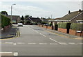
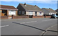
Hampshire Avenue bungalows, Newport
Viewed from the corner of Nash Road looking along Hampshire Avenue towards Hampshire Crescent.
Image: © Jaggery
Taken: 20 Apr 2016
0.05 miles
5
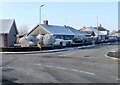
Cars and bungalows, Hampshire Avenue, Newport
Viewed from the corner of Nash Road.
Image: © Jaggery
Taken: 5 Mar 2020
0.05 miles
6
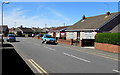
Hampshire Avenue bungalows, Newport
Between Hampshire Crescent and Nash Road. Originally, bungalow was used in English for a lightly-built house, with a veranda and one storey. In current UK usage it is a convenient word for any one-storey dwelling.
Image: © Jaggery
Taken: 20 Apr 2016
0.07 miles
7
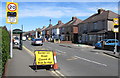
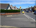
20 when lights show, Nash Road, Newport
On the approach to Lliswerry Primary School, the 30mph speed limit on Nash Road drops to 20 when the lights show (at times when children are likely to be crossing the road). In April 2016, the temporary yellow sign states that Somerton Road is closed at the railway bridge. The bridge is one of hundreds being rebuilt in preparation for the electrification of the London Paddington to South Wales main line.
Image: © Jaggery
Taken: 20 Apr 2016
0.07 miles
8
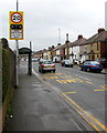
Variable speed limit on the approach to a school, Nash Road, Newport
The 30mph speed limit drops to 20mph when the lights show. The text is also in Welsh.
Image: © Jaggery
Taken: 5 Mar 2020
0.07 miles
9
Junction of Hampshire Avenue and Nash Road, Newport
Hampshire Avenue from the left joins Nash Road.
Image: © Jaggery
Taken: 20 Apr 2016
0.08 miles
10
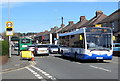
Bus on route N4, Nash Road, Newport
The N.A.T. (New Adventure Travel) single-decker is on route N4 from Market Square bus station in Newport city centre to Spytty Park, the location of Newport Retail Park.
Image: © Jaggery
Taken: 20 Apr 2016
0.08 miles