IMAGES TAKEN NEAR TO
Pembroke Grove, NEWPORT, NP19 4QG
Introduction
This page details the photographs taken nearby to Pembroke Grove, NP19 4QG by members of the Geograph project.
The Geograph project started in 2005 with the aim of publishing, organising and preserving representative images for every square kilometre of Great Britain, Ireland and the Isle of Man.

There are currently over 7.5m images from over14,400 individuals and you can help contribute to the project by visiting https://www.geograph.org.uk
Image Map
Images are licensed for reuse under creativecommons.org/licenses/by-sa/2.0
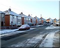
Notes
- Clicking on the map will re-center to the selected point.
- The higher the marker number, the further away the image location is from the centre of the postcode.
Image Listing (69 Images Found)
Images are licensed for reuse under creativecommons.org/licenses/by-sa/2.0
Image
Details
Distance
1
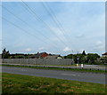
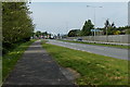
Power lines over the Southern Distributor Road, Newport
Viewed across the A48 Spytty Road (the Southern Distributor Road)
looking towards houses behind a fence in Spytty Lane.
Image: © Jaggery
Taken: 5 May 2014
0.08 miles
2
Brown Close, Newport
Located at the SE corner of an area of housing on the south side of Somerton Road where street names have a 'pioneers of aviation' theme. The close is named after Arthur Whitten Brown, who, together with John Alcock, piloted the first non-stop transatlantic flight, from Newfoundland to Ireland. The flight of 3,186 km (nearly 2,000 miles) in 1919 lasted 16 hours. Both men were knighted by King George V a few days later.
Image: © Jaggery
Taken: 10 Aug 2011
0.10 miles
3
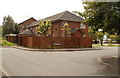
Alcock Close, Newport
Viewed from Kitty Hawk Drive. Alcock Close is part of an area of housing on the south side of Somerton Road where street names have a 'pioneers of aviation' theme. The close is named after John Alcock, who, together with Arthur Whitten Brown, piloted the first non-stop transatlantic flight, from Newfoundland to Ireland. The flight of 3,186 km (nearly 2,000 miles) in 1919 lasted 16 hours. Both men were knighted by King George V a few days later.
Image: © Jaggery
Taken: 10 Aug 2011
0.10 miles
4
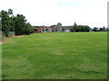
Eastern side of Liswerry recreation area, Newport
Looking towards houses in Bleriot Close from a footpath http://www.geograph.org.uk/photo/2626365 along the edge of Liswerry Pill Reen.
Image: © Jaggery
Taken: 10 Aug 2011
0.10 miles
5
Pavement on the south side of the Southern Distributor Road, Newport
Looking west along the edge of the A48 Spytty Road (the Southern Distributor Road)
City Bridge http://www.geograph.org.uk/photo/3948224 is in the background.
Image: © Jaggery
Taken: 5 May 2014
0.11 miles
6
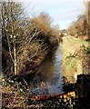
Drainage channel at the eastern edge of Reevesland Industrial Estate, Newport
Channels such as this one are a common sight in the low-lying flat land near the coast on both sides of the Bristol Channel. They are usually called reens on the northern (Welsh) side of the Bristol Channel and rhynes on the English side, such as this one http://www.geograph.org.uk/photo/3031008 in North Somerset.
Image: © Jaggery
Taken: 11 Jan 2013
0.11 miles
7
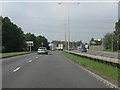
Spytty Road (A48) approaching the power lines
Image: © J Whatley
Taken: 22 Sep 2010
0.12 miles
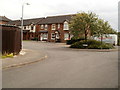
8
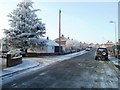
Dorset Crescent, Newport
Viewed from the Hampshire Avenue end. The turning for Dorset Close is on the left.
Image: © Jaggery
Taken: 7 Dec 2010
0.13 miles
9
Dorset Crescent houses, Newport
Houses on the south side of the crescent, opposite the junction with Hampshire Crescent.
Image: © Jaggery
Taken: 7 Dec 2010
0.13 miles
10
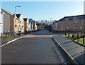
Recently-built houses in Orb Drive and St Andrew's Place, Newport
Looking south along Orb Drive past the right turn into St Andrew's Place.
Image: © Jaggery
Taken: 11 Jan 2013
0.13 miles