IMAGES TAKEN NEAR TO
Broad Mead Park, NEWPORT, NP19 4PD
Introduction
This page details the photographs taken nearby to Broad Mead Park, NP19 4PD by members of the Geograph project.
The Geograph project started in 2005 with the aim of publishing, organising and preserving representative images for every square kilometre of Great Britain, Ireland and the Isle of Man.

There are currently over 7.5m images from over14,400 individuals and you can help contribute to the project by visiting https://www.geograph.org.uk
Image Map
Images are licensed for reuse under creativecommons.org/licenses/by-sa/2.0
Notes
- Clicking on the map will re-center to the selected point.
- The higher the marker number, the further away the image location is from the centre of the postcode.
Image Listing (205 Images Found)
Images are licensed for reuse under creativecommons.org/licenses/by-sa/2.0
Image
Details
Distance
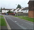
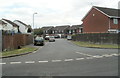
1
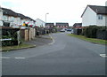
Looking along Moorland Park towards Broadmead Park, Newport
Viewed from near a giant tree http://www.geograph.org.uk/photo/2547906 at the railway perimeter fence on the northern edge of Moorland Park. The reddish-brown houses in the distance, facing the camera, are at the southern edge of Moorland Park. Behind them is Liswerry Pill Reen http://www.geograph.org.uk/photo/2547813 and Broadmead Park.
Image: © Jaggery
Taken: 10 Aug 2011
0.08 miles
2
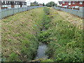
Reen is the boundary between two housing estates, Newport
The view WSW along Liswerry Pill Reen, a drainage channel. On the left are Broadmead Park houses, on the right, Moorland Park houses. The reen is the boundary for the whole of the c450 metre length of the two estates.
Image: © Jaggery
Taken: 10 Aug 2011
0.08 miles
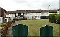
3
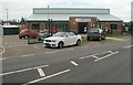
Newport East Community Centre
Located in the Moorland Park housing estate, the centre opened in 2008. It provides a variety of activities, including mother & toddler groups, boxing and sports for youngsters. The centre also caters for functions and conferences, and has a computer suite. It was built after the Newport City Council secured £670,000 of European regeneration funding.
On the day of my visit, a well-attended street party was in progress behind the centre.
Image: © Jaggery
Taken: 10 Aug 2011
0.09 miles
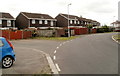
4
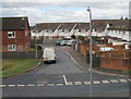
Broadmead Park houses, Newport
Houses at the SE edge of Broadmead Park, viewed from a footbridge http://www.geograph.org.uk/photo/2011307 across Spytty Road.
Image: © Jaggery
Taken: 14 Aug 2010
0.10 miles
5
Broadmead Park, Newport
Broadmead Park is an area of about 250 houses located between Moorland Park and Spytty Road.
The several roads branching from the central road are not separately named. This branch leads to houses numbered in the 130 to 190 range.
Image: © Jaggery
Taken: 5 Oct 2010
0.10 miles
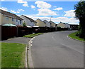
6
Houses on a bend in Moorland Park, Newport
The houses are near the western edge of Moorland Park, a 1960s housing estate on the north side of Broadmead Park.
Image: © Jaggery
Taken: 10 Aug 2011
0.10 miles
7
Moorland Park houses, Newport
Looking south from near the Liswerry Road roundabout. http://www.geograph.org.uk/photo/5022875
Image: © Jaggery
Taken: 5 Jul 2016
0.11 miles
8
Houses in the NE corner of Moorland Park, Newport
Viewed over the top of a fence, from the perimeter road. I assume the fence is there to prevent children playing on the grassy area from running into the roadway.
Moorland Park is an estate of 205 houses built in the 1960s.
Image: © Jaggery
Taken: 10 Aug 2011
0.11 miles
9
Newport : Moorland Park houses viewed from the railway perimeter fence
Moorland Park is an estate of 205 houses built in the 1960s. The several arms or spurs of houses are not separately named. Addresses are from 1 to 205 Moorland Park. This arm is near the NE corner of the estate viewed from the perimeter fence of the South Wales main railway line.
Image: © Jaggery
Taken: 10 Aug 2011
0.11 miles
10
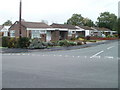
Broadcommon Close, Newport
Bungalows on the north side, viewed across Fosse Road.
Image: © Jaggery
Taken: 2 Nov 2010
0.11 miles