IMAGES TAKEN NEAR TO
Meads Close, NEWPORT, NP19 4NR
Introduction
This page details the photographs taken nearby to Meads Close, NP19 4NR by members of the Geograph project.
The Geograph project started in 2005 with the aim of publishing, organising and preserving representative images for every square kilometre of Great Britain, Ireland and the Isle of Man.

There are currently over 7.5m images from over14,400 individuals and you can help contribute to the project by visiting https://www.geograph.org.uk
Image Map
Images are licensed for reuse under creativecommons.org/licenses/by-sa/2.0
Notes
- Clicking on the map will re-center to the selected point.
- The higher the marker number, the further away the image location is from the centre of the postcode.
Image Listing (182 Images Found)
Images are licensed for reuse under creativecommons.org/licenses/by-sa/2.0
Image
Details
Distance
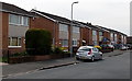
1
Mulcaster Avenue, Newport
Houses at the eastern end of Mulcaster Avenue, viewed from near the western end of Pontfaen Road.
Image: © Jaggery
Taken: 2 Nov 2010
0.02 miles
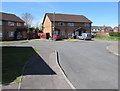
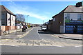
2
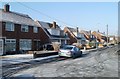
Meads Close, Newport
Houses on the west side of Meads Close, viewed from the far end looking towards Mulcaster Avenue.
Image: © Jaggery
Taken: 7 Dec 2010
0.02 miles
3
Willow Close, Newport
Willow Close is a cul-de-sac extending for 150 metres from
the south side of Mulcaster Avenue in the Liswerry area of Newport.
Image: © Jaggery
Taken: 20 Apr 2016
0.05 miles
4
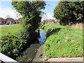
Little Spitty Reen, Liswerry, Newport
Drainage channel viewed from Fosse Road. On the north (Welsh) side of the Bristol Channel, the local word for drainage channel is reen. On the south (English) side the word is rhine or rhyne.
Image: © Jaggery
Taken: 20 Apr 2016
0.05 miles
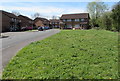
5
Fosse Road turning area, Liswerry, Newport
At the southwest end of Fosse Road.
Image: © Jaggery
Taken: 20 Apr 2016
0.06 miles
6
Southwest part of Fosse Road, Liswerry, Newport
This part of Fosse Road is south of the drainage channel named Little Spitty Reen.
Image: © Jaggery
Taken: 20 Apr 2016
0.06 miles
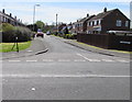
7
Fosse Road houses, Liswerry, Newport
Looking SW from the corner of Fallowfield Drive.
Image: © Jaggery
Taken: 5 May 2014
0.06 miles
8
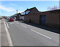
Mulcaster Avenue, Newport
East along Mulcaster Avenue from the corner of Nash Road.
A painted white triangle on the road surface draws attention to a speed bump.
Image: © Jaggery
Taken: 20 Apr 2016
0.06 miles
9
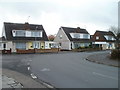
Western end of Mulcaster Avenue, Newport
Viewed across Nash Road. The corner shop is Nash Stores. http://www.geograph.org.uk/photo/4914828
Image: © Jaggery
Taken: 20 Apr 2016
0.06 miles
10
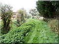
Grassy track alongside Little Spitty Reen, Newport
The track runs along the bank on the north side of the reen (drainage channel).
The name of the reen is spelt Spitty, though the nearby A road is Spytty.
Even more confusingly a larger reen nearby is Great Spytty Reen...
Image: © Jaggery
Taken: 12 Oct 2010
0.07 miles