IMAGES TAKEN NEAR TO
Mulcaster Avenue, NEWPORT, NP19 4NP
Introduction
This page details the photographs taken nearby to Mulcaster Avenue, NP19 4NP by members of the Geograph project.
The Geograph project started in 2005 with the aim of publishing, organising and preserving representative images for every square kilometre of Great Britain, Ireland and the Isle of Man.

There are currently over 7.5m images from over14,400 individuals and you can help contribute to the project by visiting https://www.geograph.org.uk
Image Map
Images are licensed for reuse under creativecommons.org/licenses/by-sa/2.0
Notes
- Clicking on the map will re-center to the selected point.
- The higher the marker number, the further away the image location is from the centre of the postcode.
Image Listing (178 Images Found)
Images are licensed for reuse under creativecommons.org/licenses/by-sa/2.0
Image
Details
Distance
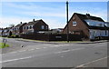
1
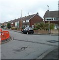
Hillview Crescent, Newport
Houses viewed from near the corner of Pontfaen Road and Mulcaster Avenue. This is the SE side of Hillview Crescent, which forms a large loop north of Mulcaster Avenue and south of Nash Grove.
Image: © Jaggery
Taken: 2 Nov 2010
0.00 miles
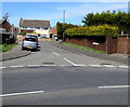
2
Mulcaster Avenue, Newport
East along Mulcaster Avenue from the corner of Nash Road.
A painted white triangle on the road surface draws attention to a speed bump.
Image: © Jaggery
Taken: 20 Apr 2016
0.04 miles
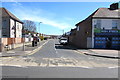
3
Hillview Crescent, Liswerry, Newport
The southeast end of Hillview Crescent viewed from the corner of
Mulcaster Avenue and Pontfaen Road in the Liswerry area of Newport.
Image: © Jaggery
Taken: 20 Apr 2016
0.04 miles
4
Western end of Mulcaster Avenue, Newport
Viewed across Nash Road. The corner shop is Nash Stores. http://www.geograph.org.uk/photo/4914828
Image: © Jaggery
Taken: 20 Apr 2016
0.05 miles
5
Corner of Willow Close and Mulcaster Avenue, Newport
Semi-detached houses viewed across Mulcaster Avenue.
Image: © Jaggery
Taken: 20 Apr 2016
0.05 miles
6
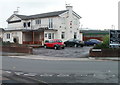
The Man of Steel, Newport
Pub on the corner of Pontfaen Road and Mulcaster Avenue, facing Greenmeadow Road.
The pub introduced a £1 'credit crunch lunch' in 2008. The white-on-black
notice on the right shows no increase in price since then: main meals £1, 2 course £2 and 3 course £3.
Image: © Jaggery
Taken: 2 Nov 2010
0.06 miles
7
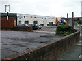
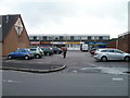
Business units, Mulcaster Avenue
A small block of business units is located at the eastern end of Mulcaster Avenue, next to The Man of Steel pub. http://www.geograph.org.uk/photo/2141878 Above the white metal door of the central unit, a sign shows DANCE CENTRE. The sign on the left shows UNITS TO LET.
Image: © Jaggery
Taken: 2 Nov 2010
0.06 miles
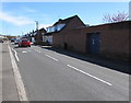
8
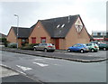
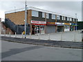
Lliswerry Medical Centre, Newport
Viewed across Pontfaen Road. The centre is on the corner of Fallowfield Drive. Behind it is a row of shops.
Image: © Jaggery
Taken: 2 Nov 2010
0.06 miles
9
Fallowfield Drive shops, Newport
Viewed from Pontfaen Road. http://www.geograph.org.uk/photo/2142008 to another view. On the left is Lliswerry Medical Centre. http://www.geograph.org.uk/photo/2141986
Image: © Jaggery
Taken: 2 Nov 2010
0.06 miles
10
Side view of Fallowfield Drive shops, Newport
Viewed across the main course of Fallowfield Drive. The shops are located on a short side branch. http://www.geograph.org.uk/photo/2141997 to the view across Pontfaen Road.
Image: © Jaggery
Taken: 2 Nov 2010
0.06 miles