IMAGES TAKEN NEAR TO
Eschol Court, NEWPORT, NP19 4LZ
Introduction
This page details the photographs taken nearby to Eschol Court, NP19 4LZ by members of the Geograph project.
The Geograph project started in 2005 with the aim of publishing, organising and preserving representative images for every square kilometre of Great Britain, Ireland and the Isle of Man.

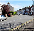
There are currently over 7.5m images from over14,400 individuals and you can help contribute to the project by visiting https://www.geograph.org.uk
Image Map
Images are licensed for reuse under creativecommons.org/licenses/by-sa/2.0
Notes
- Clicking on the map will re-center to the selected point.
- The higher the marker number, the further away the image location is from the centre of the postcode.
Image Listing (163 Images Found)
Images are licensed for reuse under creativecommons.org/licenses/by-sa/2.0
Image
Details
Distance
1
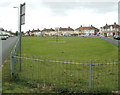
Play area between Thompson Avenue and Royston Crescent, Newport
Though it looks roughly rectangular in this view, the fenced-off play area has the shape of a somewhat distended semicircle, about 150 metres long and about 45 metres across its widest point. Royston Crescent houses are in the background.
Image: © Jaggery
Taken: 10 Aug 2011
0.02 miles
2
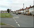
Looking east along Thompson Avenue, Newport
Viewed from the Royston Crescent junction. A children's play area http://www.geograph.org.uk/photo/2548862 is on the left.
Image: © Jaggery
Taken: 10 Aug 2011
0.02 miles
3
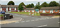
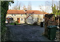
Eschol Court, Newport
Eschol Court, Eschol Close, viewed from Liswerry Road, is a sheltered house scheme.
Image: © Jaggery
Taken: 24 Sep 2009
0.05 miles
4
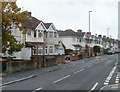
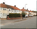
Liswerry Road, Newport
Houses on the south side of Liswerry Road, viewed from near the turning for Parfitt Street.
Image: © Jaggery
Taken: 2 Nov 2010
0.05 miles
5
Bend in Liswerry Road, Newport
Looking east from the corner of Nash Road.
Image: © Jaggery
Taken: 20 Apr 2016
0.05 miles
6
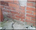
Ordnance Survey Cut Mark
This OS cut mark can be found on No2 Liswerry Road. It marks a point 7.245m above mean sea level.
Image: © Adrian Dust
Taken: 4 Aug 2021
0.06 miles
7
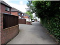
Pear Tree Lane, Liswerry, Newport
Dead-end residential lane on the north side of Liswerry Road.
Image: © Jaggery
Taken: 5 Jul 2016
0.06 miles
8
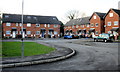
Fernside, Liswerry , Newport
Housing in Fernside, set back about 30 metres from the north side of Liswerry Road.
Image: © Jaggery
Taken: 20 Nov 2009
0.06 miles
9
Laburnum Cottages, Liswerry, Newport
Maps show the short lane leading from Liswerry Road to the cottages as
"Laburnum Bush Lane", but the only sign I saw was "Laburnum Cottages" on the corner of Liswerry Road.
Image: © Jaggery
Taken: 20 Nov 2009
0.06 miles
10
Thompson Avenue houses, Newport
Houses in this part of Thompson Avenue face Royston Crescent houses across a fenced-off grassy area used as a children's playground. http://www.geograph.org.uk/photo/2548862
Image: © Jaggery
Taken: 10 Aug 2011
0.06 miles