IMAGES TAKEN NEAR TO
Thompson Avenue, NEWPORT, NP19 4LY
Introduction
This page details the photographs taken nearby to Thompson Avenue, NP19 4LY by members of the Geograph project.
The Geograph project started in 2005 with the aim of publishing, organising and preserving representative images for every square kilometre of Great Britain, Ireland and the Isle of Man.

There are currently over 7.5m images from over14,400 individuals and you can help contribute to the project by visiting https://www.geograph.org.uk
Image Map (189 Images)


Leaflet Map data © OpenStreetMap
Images are licensed for reuse under creativecommons.org/licenses/by-sa/2.0
Notes
- Clicking on the map will re-center to the selected point.
- The higher the marker number, the further away the image location is from the centre of the postcode.
Image Listing (189 Images Found)
Images are licensed for reuse under creativecommons.org/licenses/by-sa/2.0
Image
Details
Distance
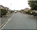
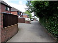
1
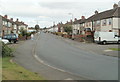
Houses at the western end of Thompson Avenue, Newport
The view east from near the corner of Churchward Drive.
Image: © Jaggery
Taken: 10 Aug 2011
0.04 miles
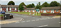
2
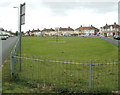
Play area between Thompson Avenue and Royston Crescent, Newport
Though it looks roughly rectangular in this view, the fenced-off play area has the shape of a somewhat distended semicircle, about 150 metres long and about 45 metres across its widest point. Royston Crescent houses are in the background.
Image: © Jaggery
Taken: 10 Aug 2011
0.04 miles
3
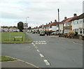
Looking east along Thompson Avenue, Newport
Viewed from the Royston Crescent junction. A children's play area http://www.geograph.org.uk/photo/2548862 is on the left.
Image: © Jaggery
Taken: 10 Aug 2011
0.04 miles
4
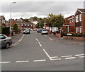
Armstrong Close, Newport
The southern end of Armstrong Close viewed from Churchward Drive, to the east of Hawksworth Grove. The three streets are named after Chief Mechanical Engineers (CME) of the Great Western Railway (GWR). Joseph Armstrong (1816-1877) was the GWR's Locomotive, Carriage and Wagon Superintendent, (the equivalent of the 20th century post of CME) from 1864-1877.
See http://www.geograph.org.uk/photo/2549431 for details of the other two men.
Image: © Jaggery
Taken: 10 Aug 2011
0.05 miles
5
Churchward Drive, Newport
The view west from the eastern edge of the Drive, named after George Jackson Churchward. http://www.geograph.org.uk/photo/2549431
Image: © Jaggery
Taken: 10 Aug 2011
0.05 miles
6
Far end of Churchward Drive, Newport
The South Wales main railway is behind the houses. The Drive is named after George Jackson Churchward. http://www.geograph.org.uk/photo/2549431
Image: © Jaggery
Taken: 10 Aug 2011
0.05 miles
7
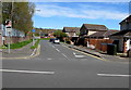
North along Thompson Avenue, Newport
Viewed across Somerton Road.
Image: © Jaggery
Taken: 20 Apr 2016
0.08 miles
8
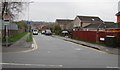
Thompson Avenue, Newport
Looking north across Somerton Road.
Image: © Jaggery
Taken: 5 Mar 2020
0.08 miles
9
Pear Tree Lane, Liswerry, Newport
Dead-end residential lane on the north side of Liswerry Road.
Image: © Jaggery
Taken: 5 Jul 2016
0.09 miles
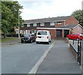
10
Eschol Court, Newport
Eschol Court, Eschol Close, viewed from Liswerry Road, is a sheltered house scheme.
Image: © Jaggery
Taken: 24 Sep 2009
0.09 miles