IMAGES TAKEN NEAR TO
Liswerry Road, NEWPORT, NP19 4LJ
Introduction
This page details the photographs taken nearby to Liswerry Road, NP19 4LJ by members of the Geograph project.
The Geograph project started in 2005 with the aim of publishing, organising and preserving representative images for every square kilometre of Great Britain, Ireland and the Isle of Man.

There are currently over 7.5m images from over14,400 individuals and you can help contribute to the project by visiting https://www.geograph.org.uk
Image Map
Images are licensed for reuse under creativecommons.org/licenses/by-sa/2.0
Notes
- Clicking on the map will re-center to the selected point.
- The higher the marker number, the further away the image location is from the centre of the postcode.
Image Listing (145 Images Found)
Images are licensed for reuse under creativecommons.org/licenses/by-sa/2.0
Image
Details
Distance
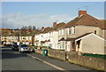
1
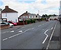
Liswerry Road speed bumps, Newport
White triangles painted on the road surface draw attention to the bumps.
Image: © Jaggery
Taken: 5 Jul 2016
0.01 miles
2
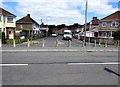
Concrete posts across Thompson Avenue, Liswerry, Newport
Viewed from Liswerry Road in July 2016. Concrete posts prevent any vehicle wider than a motorbike accessing the southeast end of Thompson Avenue. A street plan of Newport c1960 shows that this was a through route at that time.
Image: © Jaggery
Taken: 5 Jul 2016
0.02 miles
3
Rooftop solar panels, Liswerry, Newport
On a detached house on the north side of Liswerry Road.
Image: © Jaggery
Taken: 5 Jul 2016
0.02 miles
4
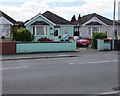
Green bungalow, Liswerry Road, Newport
A postman is making a delivery to the bungalow on the south side of Liswerry Road.
Image: © Jaggery
Taken: 5 Jul 2016
0.03 miles
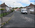
5
Thompson Avenue, Liswerry, Newport
Houses on the east side of Thompson Avenue, viewed from the Moorland Park end of Liswerry Road.
Image: © Jaggery
Taken: 20 Nov 2009
0.03 miles
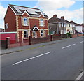
6
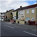
Poplar Cottages, Liswerry, Newport
On the north side of Liswerry Road.
Image: © Jaggery
Taken: 5 Jul 2016
0.04 miles
7
Thompson Avenue, Liswerry, Newport
The southeast end of Thompson Avenue, viewed from the edge of Liswerry Road.
A nearby sign shows that Thompson Avenue leads to Royston Crescent and Thompson Close.
Image: © Jaggery
Taken: 5 Jul 2016
0.05 miles
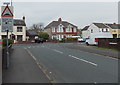
8
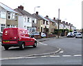
Royal Mail van on a Liswerry corner, Newport
Royal Mail van, identifier NE28, is on the corner of Liswerry Road and Moorland Avenue.
A postman is on a delivery route nearby. http://www.geograph.org.uk/photo/5024652
Image: © Jaggery
Taken: 5 Jul 2016
0.06 miles
9
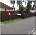
Queen Elizabeth II postbox, Greenmeadow Road, Liswerry, Newport
On the corner of Liswerry Road.
Image: © Jaggery
Taken: 5 Jul 2016
0.06 miles
10
Humps left and right along Liswerry Road, Newport
The sign is in Greenmeadow Road at the approach to the Liswerry Road junction.
Image: © Jaggery
Taken: 5 May 2014
0.06 miles