IMAGES TAKEN NEAR TO
Liswerry Road, NEWPORT, NP19 4LB
Introduction
This page details the photographs taken nearby to Liswerry Road, NP19 4LB by members of the Geograph project.
The Geograph project started in 2005 with the aim of publishing, organising and preserving representative images for every square kilometre of Great Britain, Ireland and the Isle of Man.

There are currently over 7.5m images from over14,400 individuals and you can help contribute to the project by visiting https://www.geograph.org.uk
Image Map
Images are licensed for reuse under creativecommons.org/licenses/by-sa/2.0
Notes
- Clicking on the map will re-center to the selected point.
- The higher the marker number, the further away the image location is from the centre of the postcode.
Image Listing (190 Images Found)
Images are licensed for reuse under creativecommons.org/licenses/by-sa/2.0
Image
Details
Distance
1
Eschol Court, Newport
Eschol Court, Eschol Close, viewed from Liswerry Road, is a sheltered house scheme.
Image: © Jaggery
Taken: 24 Sep 2009
0.03 miles
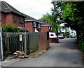
2
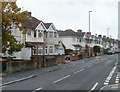
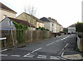
Liswerry Road, Newport
Houses on the south side of Liswerry Road, viewed from near the turning for Parfitt Street.
Image: © Jaggery
Taken: 2 Nov 2010
0.03 miles
3
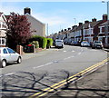
Bend in Liswerry Road, Newport
Looking east from the corner of Nash Road.
Image: © Jaggery
Taken: 20 Apr 2016
0.03 miles
4
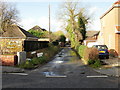
Pear Tree Lane, Liswerry, Newport
Looking from Liswerry Road along Pear Tree Lane which ends at Peartree Cottage and Myrtle Cottage.
Image: © Jaggery
Taken: 20 Nov 2009
0.03 miles
5
Parfitt Street, Liswerry, Newport
Houses on the east side of Parfitt Street, viewed from Liswerry Road.
Image: © Jaggery
Taken: 20 Nov 2009
0.03 miles
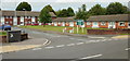
6
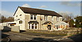
The Ferns, Liswerry, Newport
Located on Liswerry Road at the corner of Fernside. A modern pub with a large function room for family occasions or business conferences. There is also a sports bar, skittle alley and snooker room.
Image: © Jaggery
Taken: 20 Nov 2009
0.03 miles
7

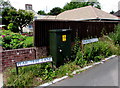
Ordnance Survey Cut Mark
This OS cut mark can be found on No2 Liswerry Road. It marks a point 7.245m above mean sea level.
Image: © Adrian Dust
Taken: 4 Aug 2021
0.04 miles
8
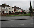
Western end of Nash Grove, Newport
Looking east across Nash Road.
Image: © Jaggery
Taken: 5 Mar 2020
0.05 miles
9
Electricity cabinet on a Liswerry corner, Newport
On the corner of Liswerry Road and Pear Tree Lane.
The manufacturers' name on the cabinet is Schneider Electric.
Among details on a label on the bottom of the cabinet is Gross Weight 177kg.
An electricity substation http://www.geograph.org.uk/photo/5024395 is nearby.
Image: © Jaggery
Taken: 5 Jul 2016
0.06 miles
10
Pear Tree Lane electricity substation, Liswerry, Newport
The Western Power Distribution electricity substation is located in the background on the left here. http://www.geograph.org.uk/photo/1589250
Confusingly, the substation identifier is ESCHOL VILLAS NPT. S/S No 531537.
Eschol Villas are nearly 100 metres to the west.
Image: © Jaggery
Taken: 5 Jul 2016
0.06 miles