IMAGES TAKEN NEAR TO
Somerton Road, NEWPORT, NP19 4JZ
Introduction
This page details the photographs taken nearby to Somerton Road, NP19 4JZ by members of the Geograph project.
The Geograph project started in 2005 with the aim of publishing, organising and preserving representative images for every square kilometre of Great Britain, Ireland and the Isle of Man.

There are currently over 7.5m images from over14,400 individuals and you can help contribute to the project by visiting https://www.geograph.org.uk
Image Map
Images are licensed for reuse under creativecommons.org/licenses/by-sa/2.0
Notes
- Clicking on the map will re-center to the selected point.
- The higher the marker number, the further away the image location is from the centre of the postcode.
Image Listing (181 Images Found)
Images are licensed for reuse under creativecommons.org/licenses/by-sa/2.0
Image
Details
Distance
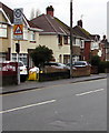
1
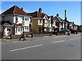
Somerton Road houses, Newport
On the north side of Somerton Road, between Thompson Avenue and Liswerry Road.
Image: © Jaggery
Taken: 20 Apr 2016
0.01 miles
2
From Liswerry Road to Somerton Road, Newport
Viewed from the corner of Nash Road.
The Liswerry Road name sign is in front of the hedge on the right.
The Somerton Road name sign is behind the Zone Ends sign.
Image: © Jaggery
Taken: 20 Apr 2016
0.01 miles
3
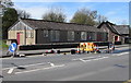
Roadworks alongside St Andrew's Church Hall, Newport
Viewed across Somerton Road on April 20th 2016 during a period of rainless anticyclonic weather.
The wet patch on the road suggests that the work is on a leaking underground water pipe.
Image: © Jaggery
Taken: 20 Apr 2016
0.02 miles
4
From Somerton Road to Liswerry Road, Newport
The Somerton Road name sign is on the low wall on the left.
The Liswerry Road name sign is behind Keep Left signs.
Image: © Jaggery
Taken: 5 Mar 2020
0.02 miles
5
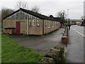
St Andrew's church hall, Somerton Road, Newport
The hall is on the east side of St Andrew's Church. https://www.geograph.org.uk/photo/4915201
Image: © Jaggery
Taken: 5 Mar 2020
0.02 miles
6
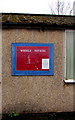
Weekly Notices board on the wall of St Andrew's Church Hall, Newport
The only notice on the board on this https://www.geograph.org.uk/photo/4915218St building in March 2020 shows that St Andrew's Church services take place every Sunday at 10 o'clock.
Image: © Jaggery
Taken: 5 Mar 2020
0.02 miles
7
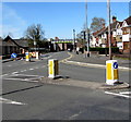
Pedestrian refuge in Liswerry Road, Newport
At the western end of Liswerry Road, opposite the Somerton Road junction.
When the road is busy, the refuge lets walkers cross half the road width at a time.
Image: © Jaggery
Taken: 20 Apr 2016
0.02 miles
8
Keep Left sign at the western end of Liswerry Road, Newport
Facing the NW end of Nash Road and the SE end of Somerton Road.
Image: © Jaggery
Taken: 5 Mar 2020
0.02 miles
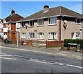
9
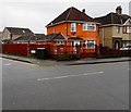
Orange house on a Newport corner
Conspicuous house on the corner of Somerton Road and Thompson Avenue viewed in March 2020.
Image: © Jaggery
Taken: 5 Mar 2020
0.03 miles
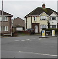
10
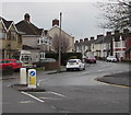
20 Zone sign, Somerton Road, Newport
20mph speed limit on the approach to Lliswerry Primary School. PARTH is Welsh for ZONE.
Image: © Jaggery
Taken: 5 Mar 2020
0.03 miles