IMAGES TAKEN NEAR TO
Severn Sisters Close, NEWPORT, NP19 4AX
Introduction
This page details the photographs taken nearby to Severn Sisters Close, NP19 4AX by members of the Geograph project.
The Geograph project started in 2005 with the aim of publishing, organising and preserving representative images for every square kilometre of Great Britain, Ireland and the Isle of Man.

There are currently over 7.5m images from over14,400 individuals and you can help contribute to the project by visiting https://www.geograph.org.uk
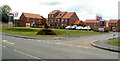
Image Map
Images are licensed for reuse under creativecommons.org/licenses/by-sa/2.0
Notes
- Clicking on the map will re-center to the selected point.
- The higher the marker number, the further away the image location is from the centre of the postcode.
Image Listing (61 Images Found)
Images are licensed for reuse under creativecommons.org/licenses/by-sa/2.0
Image
Details
Distance
1
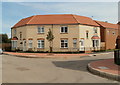
Corner of Lysaght Way and Lysaght Avenue, Newport
Viewed across Lysaght Way. The newly-built housing is in Lysaght Village. http://www.geograph.org.uk/photo/2539967
Image: © Jaggery
Taken: 5 Aug 2011
0.06 miles
2
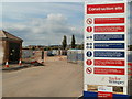
Construction site entrance, Lysaght Village, Newport
The large Taylor Wimpey notice is at the entrance to the site. http://www.geograph.org.uk/photo/2540069
Among the various statements and warnings is "Remember: no safety helmet, no safety boots, no high visibility vests, no safety training = no job".
Image: © Jaggery
Taken: 5 Aug 2011
0.06 miles
3
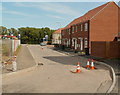
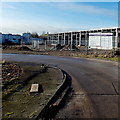
Dividing line between houses and building site, Lysaght Village, Newport
The view is towards Corporation Road. Currently (early August 2011), Lysaght Way is the boundary between houses on the right and a fenced-off building site on the left.
Image: © Jaggery
Taken: 5 Aug 2011
0.06 miles
4
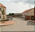
Lysaght Avenue, Lysaght Village, Newport
Newly-built houses in Lysaght Avenue, viewed from Lysaght Way. Lysaght Village occupies a site formerly part of Orb steelworks. http://www.geograph.org.uk/photo/1621101
Image: © Jaggery
Taken: 5 Aug 2011
0.06 miles
5
Lysaght Way, Lysaght Village, Newport
Newly-built houses viewed across Corporation Road. Lysaght Village occupies land http://www.geograph.org.uk/photo/1621101 formerly part of Orb steelworks.
Image: © Jaggery
Taken: 5 Aug 2011
0.06 miles
6

Lysaght Circle, Lysaght Village, Newport
Recently-built houses on the Taylor Wimpey housing development on land formerly
in the NE corner of the Tata Steel Orb steelworks site (originally Lysaght Orb steelworks).
Image: © Jaggery
Taken: 5 May 2014
0.07 miles
7
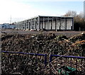
A shell of a building in The Newport Business Centre
Viewed from Corporation Road. There is a mound of earth and other debris outside this building at the northern edge of The Newport Business Centre. To this non-expert eye, the building looks more like a framework, almost as if made from scaffolding.
Image: © Jaggery
Taken: 11 Jan 2013
0.08 miles
8
Businesses location board in The Newport Business Centre
Facing the entrance from Corporation Road, a large board shows where each business is in the site.
Image: © Jaggery
Taken: 11 Jan 2013
0.09 miles
9
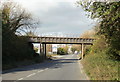
Railway bridge, Corporation Road, Newport
The bridge carries a single track industrial railway line across Corporation Road.
Image: © Jaggery
Taken: 5 Nov 2009
0.10 miles
10
Corporation Road drainage channel, Newport
Viewed from the entrance to The Newport Business Centre looking north towards this http://www.geograph.org.uk/photo/3330365 railway bridge. Maps show many such drainage channels in the flat land hereabouts, but some are fragmentary, or perhaps appear so on maps where their course is underground. There is more junk than water in this channel, where only a few small puddles can be seen.
Image: © Jaggery
Taken: 11 Jan 2013
0.10 miles