IMAGES TAKEN NEAR TO
Corporation Road, NEWPORT, NP19 0XB
Introduction
This page details the photographs taken nearby to Corporation Road, NP19 0XB by members of the Geograph project.
The Geograph project started in 2005 with the aim of publishing, organising and preserving representative images for every square kilometre of Great Britain, Ireland and the Isle of Man.

There are currently over 7.5m images from over14,400 individuals and you can help contribute to the project by visiting https://www.geograph.org.uk
Image Map
Images are licensed for reuse under creativecommons.org/licenses/by-sa/2.0
Notes
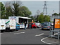
- Clicking on the map will re-center to the selected point.
- The higher the marker number, the further away the image location is from the centre of the postcode.
Image Listing (106 Images Found)
Images are licensed for reuse under creativecommons.org/licenses/by-sa/2.0
Image
Details
Distance
1
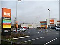
B & Q Mini Warehouse, Corporation Road
Image: © Robin Drayton
Taken: 9 Dec 2009
0.04 miles
2
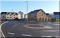
Recently-built houses, Orb Drive, Newport
The houses are near Morrisons superstore http://www.geograph.org.uk/photo/2651720 to the east of Corporation Road.
Image: © Jaggery
Taken: 11 Jan 2013
0.05 miles
3
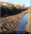
Drainage channel alongside B&Q store, Newport
Viewed from Orb Drive. The channel runs past the eastern edge of this http://www.geograph.org.uk/photo/1621542 Corporation Road B&Q.
Image: © Jaggery
Taken: 11 Jan 2013
0.05 miles
4
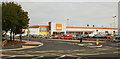
B&Q, Corporation Road, Newport
Opened on May 1st 2009, replacing its store in Maesglas Retail Park, which was only half the size of this one, and is now a Buyology Discount Store. http://www.geograph.org.uk/photo/1995668
Image: © Jaggery
Taken: 23 Sep 2009
0.06 miles
5
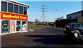
Pylon near Liswerry Pumping Station, Newport
Viewed from the edge of Corporation Road, looking between Bathwick Tyres premises on the left http://www.geograph.org.uk/photo/1621526 and Liswerry Pumping Station http://www.geograph.org.uk/photo/1621536 on the right.
Image: © Jaggery
Taken: 11 Jan 2013
0.06 miles
6
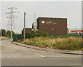
Liswerry Pumping Station, Newport
Located on the east side of Corporation Road, between Colston Avenue and Spytty Road.
Image: © Jaggery
Taken: 23 Sep 2009
0.06 miles
7
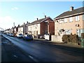
Colston Avenue, Newport
Houses on the NW side of the avenue, viewed from Colston Place, looking towards Corporation Road.
Just visible at the left edge of the view is the City Bridge. http://www.geograph.org.uk/photo/557828
Image: © Jaggery
Taken: 15 Dec 2010
0.06 miles
8
Looking towards W.R. Lysaght Institute
Image: © Nick Mutton 01329 000000
Taken: 7 Oct 2007
0.06 miles
9
Alana's Diner, Newport
Fast food stall at the edge of the Corporation Road B&Q superstore's car park.
Image: © Jaggery
Taken: 5 May 2014
0.07 miles
10
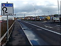
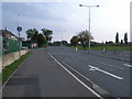
No right turn 30 yards ahead, Orb Drive, Newport
Viewed from the corner of Corporation Road. This sign wasn't here on my last visit a few weeks earlier. Presumably it has been installed because of the number of vehicles using the Morrisons site on the right to turn around, rather than the route indicated on this sign.
Image: © Jaggery
Taken: 14 Feb 2013
0.07 miles