IMAGES TAKEN NEAR TO
Wright Close, NEWPORT, NP19 0RW
Introduction
This page details the photographs taken nearby to Wright Close, NP19 0RW by members of the Geograph project.
The Geograph project started in 2005 with the aim of publishing, organising and preserving representative images for every square kilometre of Great Britain, Ireland and the Isle of Man.

There are currently over 7.5m images from over14,400 individuals and you can help contribute to the project by visiting https://www.geograph.org.uk
Image Map
Images are licensed for reuse under creativecommons.org/licenses/by-sa/2.0
Notes
- Clicking on the map will re-center to the selected point.
- The higher the marker number, the further away the image location is from the centre of the postcode.
Image Listing (165 Images Found)
Images are licensed for reuse under creativecommons.org/licenses/by-sa/2.0
Image
Details
Distance
1
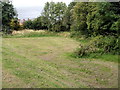
Small depression on the east side of Kitty Hawk Drive, Newport
A roughly triangular area of land is about a metre below road level. On the right are trees at the edge of a single-track railway line. Out of shot on the left is the junction of Wright Close and Kitty Hawk Drive.
Image: © Jaggery
Taken: 10 Aug 2011
0.01 miles
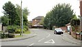
2
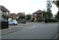
Wright Close, Newport
Viewed from the edge of Kitty Hawk Drive, Wright Close is located in an area of housing on the south side of Somerton Road where street names have a 'pioneers of aviation' theme. Perhaps the most famous of the pioneers, the Wright brothers (Wilbur and Orville) made the first controlled, powered and sustained heavier-than-air human flight near Kitty Hawk, North Carolina, USA, on December 17, 1903.
Image: © Jaggery
Taken: 10 Aug 2011
0.01 miles
3
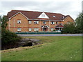
Abbeyfield House, Newport
Located in Reene Court. Since 1956, Abbeyfield has provided supported sheltered housing, and now has more than 700 housing locations in the UK. The housing is intended for those of pensionable age who no longer feel able to cope, or do not wish to live at home alone.
Image: © Jaggery
Taken: 10 Aug 2011
0.01 miles
4
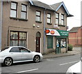
Liswerry Post Office, Newport
Post Office on the corner of Somerton Road and Kitty Hawk Drive.
Image: © Jaggery
Taken: 24 Sep 2009
0.06 miles
5
Kitty Hawk Drive, Newport
Viewed from the corner of Somerton Road, Kitty Hawk Drive is the connecting road through an area of modern houses with aviation-themed street names, such as Amy Johnson Close and Bleriot Close.
Image: © Jaggery
Taken: 24 Sep 2009
0.06 miles
6
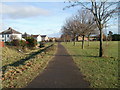
Footpath along northern edge of Liswerry Recreation Ground, Newport
The footpath is between Liswerry Pill Reen (drainage channel) http://www.geograph.org.uk/photo/2199165 on the left, and the tree-lined recreation ground.
Image: © Jaggery
Taken: 15 Dec 2010
0.06 miles
7
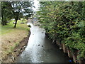
Liswerry Pill Reen, Newport
The reen (drainage channel) is here at the northern edge of a recreation ground.
The houses in the distance are at the southern edge of Downing Street.
Image: © Jaggery
Taken: 10 Aug 2011
0.06 miles
8
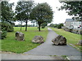
Boulders block vehicular access to Liswerry recreation area, Newport
Viewed from near Reene Court. The footpath ahead runs alongside Liswerry Pill Reen (drainage channel). http://www.geograph.org.uk/photo/2626355
Image: © Jaggery
Taken: 10 Aug 2011
0.06 miles
9
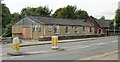
St Andrews church hall, Newport
On Somerton Road, between Nash Road and Thompson Avenue. St Andrews church is at the far end of the hall in this view looking west.
Image: © Jaggery
Taken: 24 Sep 2009
0.06 miles
10
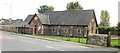
St Andrews, Liswerry, Newport
St Andrews Church in Wales church, built in 1883, is on Somerton Road.
Image: © Jaggery
Taken: 24 Sep 2009
0.06 miles