IMAGES TAKEN NEAR TO
Coverack Road, NP19 0QE
Introduction
This page details the photographs taken nearby to Coverack Road, NP19 0QE by members of the Geograph project.
The Geograph project started in 2005 with the aim of publishing, organising and preserving representative images for every square kilometre of Great Britain, Ireland and the Isle of Man.

There are currently over 7.5m images from over14,400 individuals and you can help contribute to the project by visiting https://www.geograph.org.uk
Image Map
Images are licensed for reuse under creativecommons.org/licenses/by-sa/2.0
Notes
- Clicking on the map will re-center to the selected point.
- The higher the marker number, the further away the image location is from the centre of the postcode.
Image Listing (362 Images Found)
Images are licensed for reuse under creativecommons.org/licenses/by-sa/2.0
Image
Details
Distance
1
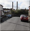
Towards railings at the dead end of Cyril Street, Newport
About 170 metres from the Corporation Road junction, Cyril Street ends at railings.
George Street Bridge support towers are in the background.
Image: © Jaggery
Taken: 11 Mar 2020
0.01 miles
2
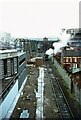
'Faraday' at Newport Power Station ? 1967
The power station was originally that of Newport Corporation, but run by the Central Electricity Generating Board after nationalisation. 'Faraday' was built by Hawthorn Leslie of Newcastle (works no 3793) in 1932 and was used for bringing coal into the power station.
Image: © Alan Murray-Rust
Taken: 17 Dec 1967
0.02 miles
3
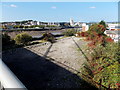
Vacant riverbank site in Newport
Viewed from George Street bridge. There used to be an industrial building here, between Morris Street and the River Usk.
Image: © Jaggery
Taken: 21 Sep 2014
0.02 miles
4
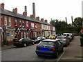
Cyril Street,Newport
Viewed from Corporation Road. The tops of the towers of the George Street bridge can be seen in the background.
Image: © Jaggery
Taken: 13 Aug 2009
0.02 miles
5
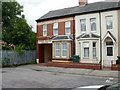
Stephen Williams Upholstery, Cyril St, Newport
Tucked right up against the railings at the far end of Cyril Street is Stephen Williams Upholstery.
Image: © Jaggery
Taken: 13 Aug 2009
0.02 miles
6
George Street Bridge
View from George Street Bridge in Newport looking towards Cyril Street.
Image: © Wayland Smith
Taken: 15 Oct 2016
0.04 miles
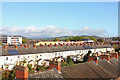
7
Rooftop view from George Street bridge, Newport
Looking across the rooftops of Morris Street and Cyril Street, from George Street bridge.
Image: © Jaggery
Taken: 13 Aug 2009
0.04 miles
8
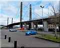
George Street Bridge viewed from the edge of Usk Way, Newport
The bridge across the River Usk opened in April 1964. http://www.geograph.org.uk/photo/3073407
It is the first cable-stayed bridge in the United Kingdom.
Image: © Jaggery
Taken: 13 Mar 2013
0.04 miles
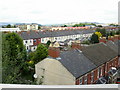
9
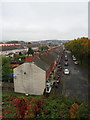
Houses on Morris Street, Newport
View down from George Street Bridge.
Image: © JThomas
Taken: 15 Oct 2019
0.05 miles
10

Ordnance Survey Cut Mark
This OS cut mark can be found on the NE tower of George Street Bridge. It marks a point 20.537m above mean sea level.
Image: © Adrian Dust
Taken: 9 Jun 2018
0.05 miles