IMAGES TAKEN NEAR TO
Bathstone Mews, NEWPORT, NP19 0PU
Introduction
This page details the photographs taken nearby to Bathstone Mews, NP19 0PU by members of the Geograph project.
The Geograph project started in 2005 with the aim of publishing, organising and preserving representative images for every square kilometre of Great Britain, Ireland and the Isle of Man.

There are currently over 7.5m images from over14,400 individuals and you can help contribute to the project by visiting https://www.geograph.org.uk
Image Map
Images are licensed for reuse under creativecommons.org/licenses/by-sa/2.0
Notes
- Clicking on the map will re-center to the selected point.
- The higher the marker number, the further away the image location is from the centre of the postcode.
Image Listing (2207 Images Found)
Images are licensed for reuse under creativecommons.org/licenses/by-sa/2.0
Image
Details
Distance
1
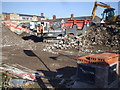
Windowless brick building, Rodney Road, Newport
Part of a Taylor Wimpey construction site viewed on October 1st 2016.
Image: © Jaggery
Taken: 1 Oct 2016
0.00 miles
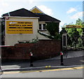
2
An entrance to Newport Rugby Club
On the corner of Rodney Road and Grafton Road. The inscription on a triangular part of the roof reads Newport Rugby Club 1875.
Image: © Jaggery
Taken: 30 Aug 2009
0.01 miles
3
Grafton Road, Newport
Looking towards Rodney Road from Corporation Road.
Image: © Jaggery
Taken: 30 Aug 2009
0.01 miles
4
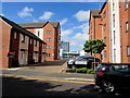
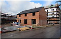
Bathstone Mews, Newport
Flats built on the east bank of the River Usk in the second decade of the 21st century viewed across Rodney Road in May 2020. The name sign on the right shows that Bathstone Mews is Cowrt Carreg Caerfaddon in Welsh.
Image: © Jaggery
Taken: 11 May 2020
0.01 miles
5

RAS white van, Rodney Road, Newport
RAS is the acronym of Retail Asset Solutions.
Image: © Jaggery
Taken: 11 May 2020
0.02 miles
6
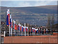
Newport: site for new homes by the river
Alternating red and blue flags of the housing firm Taylor Wimpey fly along the edge of a site which will soon have new homes built upon it. This western edge of the site follows the very gentle curve of the River Usk, just to our left.
Image: © Chris Downer
Taken: 18 Feb 2012
0.02 miles
7
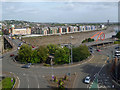
Old Green Roundabout, Newport (2017)
For a similar view taken 10 years earlier see http://www.geograph.org.uk/photo/494538 .
The main change here has been redevelopment along the far bank of the River Usk.
The Grade II Listed former Newport Art College, by the bridge on the left, has been renovated and now contains 66 one and two bedroom apartments that were completed in 2012.
There is now a riverside walkway and housing, completed in 2017, along all of the east bank of the River Usk in this view and beyond.
Image: © Robin Drayton
Taken: 6 Sep 2017
0.02 miles
8
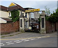
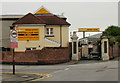
Newport Rugby Club War Memorial Gates
On the corner of Rodney Road and Grafton Road, at an entrance to Rodney Parade.
The years 1914 and 1918 are near the top of the gates.
The inscription on the yellow triangle on the roof is NEWPORT RUGBY CLUB 1875.
Image: © Jaggery
Taken: 6 May 2017
0.02 miles
9
Yellow direction sign, Grafton Road, Newport
The black arrow points left along Grafton Road towards Newport Rugby Club's ticket office, reception & club shop. War Memorial gates are on the right. https://www.geograph.org.uk/photo/5381716
Image: © Jaggery
Taken: 11 May 2020
0.02 miles