IMAGES TAKEN NEAR TO
Baroque Court, NEWPORT, NP19 0PR
Introduction
This page details the photographs taken nearby to Baroque Court, NP19 0PR by members of the Geograph project.
The Geograph project started in 2005 with the aim of publishing, organising and preserving representative images for every square kilometre of Great Britain, Ireland and the Isle of Man.

There are currently over 7.5m images from over14,400 individuals and you can help contribute to the project by visiting https://www.geograph.org.uk
Image Map
Images are licensed for reuse under creativecommons.org/licenses/by-sa/2.0
Notes
- Clicking on the map will re-center to the selected point.
- The higher the marker number, the further away the image location is from the centre of the postcode.
Image Listing (1751 Images Found)
Images are licensed for reuse under creativecommons.org/licenses/by-sa/2.0
Image
Details
Distance
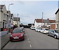
1
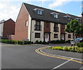
Corner of Rodney Road and Baroque Court, Newport
Viewed across Rodney Road. The bilingual name sign on
the corner shows that Baroque Court is Llys Baroc in Welsh.
Image: © Jaggery
Taken: 11 May 2020
0.00 miles
2
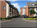
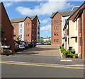
Baroque Court, Newport
Flats built on the east bank of the River Usk in the second decade of the 21st century viewed across Rodney Road in May 2020. The bilingual name sign on the left shows Baroque Court is Llys Baroc in Welsh.
Image: © Jaggery
Taken: 11 May 2020
0.02 miles
3
Corner of Rodney Road and Edwardian Mews, Newport
Viewed across Rodney Road. The bilingual name sign on the corner shows that Edwardian Mews is Cowrt Edwardaidd in Welsh.
Image: © Jaggery
Taken: 11 May 2020
0.02 miles
4
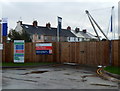
City Vizion building site, Newport
Viewed from Rodney Road. City Vizion is a Taylor Wimpey development of new houses on the east bank of the River Usk. The Colne Street houses in the background are not part of the development.
Also in the background are the masts of Newport City Footbridge. http://www.geograph.org.uk/photo/1477359
Image: © Jaggery
Taken: 25 Nov 2012
0.03 miles
5

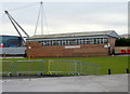
Entrance to Gates 3,4 & 7 at Rodney Parade, Newport
Viewed across Rodney Road from the corner of Colne Street. Rodney Parade is the home ground of rugby union clubs Newport RFC and the Newport Gwent Dragons regional team. It is also the home ground of Newport County football club, and is the second-oldest sports venue in the Football League, after Deepdale in Preston.
However, this has been Newport County's home ground only since 2012. By far their longest duration (1912-1989) home was at Somerton Park in the east side of Newport.
Image: © Jaggery
Taken: 6 May 2017
0.03 miles
6
Newport Squash Club
Newport Squash Rackets Club moved to its current home here inside Rodney Parade http://www.geograph.org.uk/photo/3244114 in 1971. There are four national standard courts and a Pro Shop that provides everything a player needs including a wide range of specialist equipment and clothing brands, plus a racket restringing service.
In the background are the masts http://www.geograph.org.uk/photo/1477359 of Newport City Footbridge.
Image: © Jaggery
Taken: 25 Nov 2012
0.03 miles
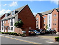
7
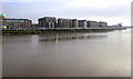
Housing on the east bank of the River Usk, Newport
Viewed in January 2017. The green dome on the left is on top of a former arts college which was converted to flats several years ago. The other housing is part of the Renaissance Point development in Rodney Road.
Image: © Jaggery
Taken: 19 Jan 2017
0.03 miles
8
Edwardian Mews, Newport
Flats built on the east bank of the River Usk in the second decade of the 21st century viewed across Rodney Road in May 2020. The bilingual name sign on the left shows that Edwardian Mews is Cowrt Edwardaidd in Welsh.
Image: © Jaggery
Taken: 11 May 2020
0.03 miles
9
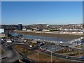
View north-east from the top of the Kingsway Car Park
Looking across the river Usk and showing the walkway that has been constructed along the east bank but is not yet open.
New residential housing is planned for this area.
Image: © Robin Drayton
Taken: 8 Mar 2010
0.03 miles
10
Colne Street, Newport
Along Colne Street towards Rodney Road. Broken white lines mark parking areas on both sides of the street.
Image: © Jaggery
Taken: 6 May 2017
0.04 miles